You are here: Home > Network List > OH - Ohio Seismic Network Stations List
> Station P51A Williamsport, OH, USA > Earthquake Result Viewer
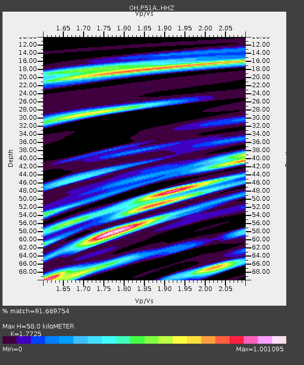
P51A Williamsport, OH, USA - Earthquake Result Viewer
| Earthquake location: |
Iceland Region |
| Earthquake latitude/longitude: |
66.4/-18.7 |
| Earthquake time(UTC): |
2020/06/21 (173) 19:07:55 GMT |
| Earthquake Depth: |
10 km |
| Earthquake Magnitude: |
6.0 mww |
| Earthquake Catalog/Contributor: |
NEIC PDE/us |
|
| Network: |
OH Ohio Seismic Network |
| Station: |
P51A Williamsport, OH, USA |
| Lat/Lon: |
39.48 N/83.06 W |
| Elevation: |
211 m |
|
| Distance: |
44.4 deg |
| Az: |
265.795 deg |
| Baz: |
31.268 deg |
| Ray Param: |
0.07195648 |
| Estimated Moho Depth: |
58.0 km |
| Estimated Crust Vp/Vs: |
1.77 |
| Assumed Crust Vp: |
6.232 km/s |
| Estimated Crust Vs: |
3.516 km/s |
| Estimated Crust Poisson's Ratio: |
0.27 |
|
| Radial Match: |
91.669754 % |
| Radial Bump: |
321 |
| Transverse Match: |
67.64404 % |
| Transverse Bump: |
400 |
| SOD ConfigId: |
21709731 |
| Insert Time: |
2020-07-05 19:31:51.024 +0000 |
| GWidth: |
2.5 |
| Max Bumps: |
400 |
| Tol: |
0.001 |
|

Signal To Noise
| Channel | StoN | STA | LTA |
| OH:P51A: :HHZ:20200621T19:15:34.830004Z | 12.136256 | 5.964547E-7 | 4.9146518E-8 |
| OH:P51A: :HHN:20200621T19:15:34.830004Z | 3.4014633 | 3.5465908E-7 | 1.0426662E-7 |
| OH:P51A: :HHE:20200621T19:15:34.830004Z | 3.3430567 | 1.8977549E-7 | 5.6767057E-8 |
| Arrivals |
| Ps | 7.6 SECOND |
| PpPs | 24 SECOND |
| PsPs/PpSs | 32 SECOND |


