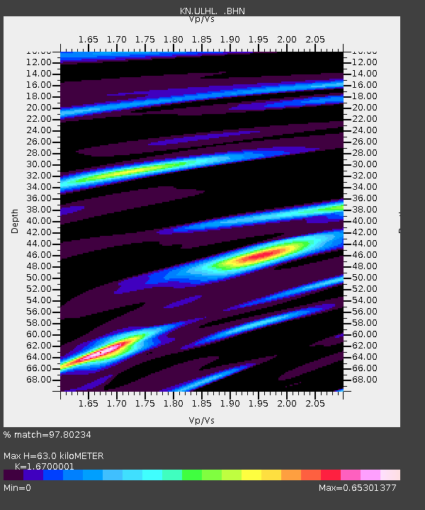
ULHL KN.ULHL - Earthquake Result Viewer

Earthquake location: New Britain Region, P.N.G.
Earthquake latitude/longitude: -5.5/151.8
Earthquake time(UTC): 2000/11/17 (322) 21:01:56 GMT
Earthquake Depth: 33 km
Earthquake Magnitude: 6.2 MB, 8.0 MS, 7.6 MW, 6.9 ME
Earthquake Catalog/Contributor: WHDF/NEIC
Network: KN Kyrgyz Seismic Telemetry Network
Station: ULHL KN.ULHL
Lat/Lon: 42.25 N/76.24 E
Elevation: 2040 m
Distance: 83.1 deg
Az: 313.59 deg
Baz: 103.822 deg
Ray Param: 0.046412263
Estimated Moho Depth: 63.0 km
Estimated Crust Vp/Vs: 1.67
Assumed Crust Vp: 6.306 km/s
Estimated Crust Vs: 3.776 km/s
Estimated Crust Poisson's Ratio: 0.22
Radial Match: 97.80234 %
Radial Bump: 295
Transverse Match: 91.53521 %
Transverse Bump: 400
SOD ConfigId: 3744
Insert Time: 2010-03-08 21:55:28.620 +0000
GWidth: 2.5
Max Bumps: 400
Tol: 0.001

Signal To Noise

ChannelStoNSTALTA
KN:ULHL: :BHN:20001117T21:13:47.50001Z1.38288032.2093626E-71.5976528E-7
KN:ULHL: :BHE:20001117T21:13:47.50001Z1.6321222.1343736E-71.3077292E-7
KN:ULHL: :BHZ:20001117T21:13:47.50001Z3.49167976.9900744E-72.0019232E-7
Arrivals
Ps6.9 SECOND
PpPs26 SECOND
PsPs/PpSs33 SECOND