You are here: Home > Network List > PO - Portable Observatories for Lithospheric Analysis and Research Investigating Seis Stations List
> Station NMSQ Nemaska Station, QC, CA > Earthquake Result Viewer
NMSQ Nemaska Station, QC, CA - Earthquake Result Viewer
| Earthquake location: |
Iceland Region |
| Earthquake latitude/longitude: |
66.4/-18.7 |
| Earthquake time(UTC): |
2020/06/21 (173) 19:07:55 GMT |
| Earthquake Depth: |
10 km |
| Earthquake Magnitude: |
6.0 mww |
| Earthquake Catalog/Contributor: |
NEIC PDE/us |
|
| Network: |
PO Portable Observatories for Lithospheric Analysis and Research Investigating Seis |
| Station: |
NMSQ Nemaska Station, QC, CA |
| Lat/Lon: |
51.71 N/76.02 W |
| Elevation: |
275 m |
|
| Distance: |
31.6 deg |
| Az: |
270.875 deg |
| Baz: |
40.34 deg |
| Ray Param: |
0.079018585 |
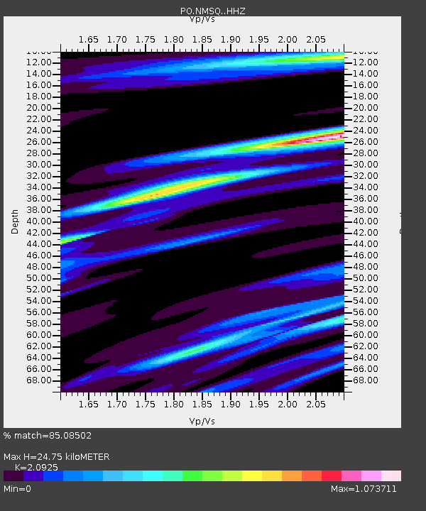
| Estimated Moho Depth: |
24.75 km |
| Estimated Crust Vp/Vs: |
2.09 |
| Assumed Crust Vp: |
6.459 km/s |
| Estimated Crust Vs: |
3.087 km/s |
| Estimated Crust Poisson's Ratio: |
0.35 |
|
| Radial Match: |
85.08502 % |
| Radial Bump: |
291 |
| Transverse Match: |
68.68102 % |
| Transverse Bump: |
400 |
| SOD ConfigId: |
21709731 |
| Insert Time: |
2020-07-05 19:33:17.449 +0000 |
| GWidth: |
2.5 |
| Max Bumps: |
400 |
| Tol: |
0.001 |
|

Signal To Noise
| Channel | StoN | STA | LTA |
| PO:NMSQ: :HHZ:20200621T19:13:47.085985Z | 2.5677042 | 7.0418923E-7 | 2.7424858E-7 |
| PO:NMSQ: :HHN:20200621T19:13:47.085985Z | 7.9373264 | 4.5570437E-7 | 5.741283E-8 |
| PO:NMSQ: :HHE:20200621T19:13:47.085985Z | 3.355264 | 2.6067994E-7 | 7.769283E-8 |
| Arrivals |
| Ps | 4.5 SECOND |
| PpPs | 11 SECOND |
| PsPs/PpSs | 16 SECOND |


