You are here: Home > Network List > TA - USArray Transportable Network (new EarthScope stations) Stations List
> Station A22K Sinclair Lake, AK, USA > Earthquake Result Viewer
A22K Sinclair Lake, AK, USA - Earthquake Result Viewer
| Earthquake location: |
Iceland Region |
| Earthquake latitude/longitude: |
66.4/-18.7 |
| Earthquake time(UTC): |
2020/06/21 (173) 19:07:55 GMT |
| Earthquake Depth: |
10 km |
| Earthquake Magnitude: |
6.0 mww |
| Earthquake Catalog/Contributor: |
NEIC PDE/us |
|
| Network: |
TA USArray Transportable Network (new EarthScope stations) |
| Station: |
A22K Sinclair Lake, AK, USA |
| Lat/Lon: |
71.00 N/154.97 W |
| Elevation: |
6.0 m |
|
| Distance: |
39.7 deg |
| Az: |
339.247 deg |
| Baz: |
25.838 deg |
| Ray Param: |
0.074838236 |
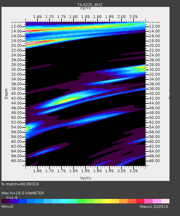
| Estimated Moho Depth: |
19.0 km |
| Estimated Crust Vp/Vs: |
1.60 |
| Assumed Crust Vp: |
5.782 km/s |
| Estimated Crust Vs: |
3.614 km/s |
| Estimated Crust Poisson's Ratio: |
0.18 |
|
| Radial Match: |
90.99316 % |
| Radial Bump: |
303 |
| Transverse Match: |
85.18984 % |
| Transverse Bump: |
400 |
| SOD ConfigId: |
21709731 |
| Insert Time: |
2020-07-05 19:34:27.240 +0000 |
| GWidth: |
2.5 |
| Max Bumps: |
400 |
| Tol: |
0.001 |
|
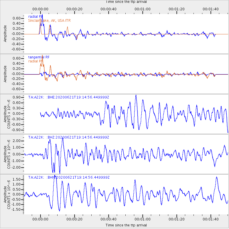
Signal To Noise
| Channel | StoN | STA | LTA |
| TA:A22K: :BHZ:20200621T19:14:56.449999Z | 5.824456 | 5.6424165E-7 | 9.6874565E-8 |
| TA:A22K: :BHN:20200621T19:14:56.449999Z | 0.8328726 | 1.0680418E-7 | 1.2823591E-7 |
| TA:A22K: :BHE:20200621T19:14:56.449999Z | 0.69657004 | 7.719195E-8 | 1.1081721E-7 |
| Arrivals |
| Ps | 2.1 SECOND |
| PpPs | 8.0 SECOND |
| PsPs/PpSs | 10 SECOND |


