You are here: Home > Network List > TA - USArray Transportable Network (new EarthScope stations) Stations List
> Station E21K Killik River, AK, USA > Earthquake Result Viewer
E21K Killik River, AK, USA - Earthquake Result Viewer
| Earthquake location: |
Iceland Region |
| Earthquake latitude/longitude: |
66.4/-18.7 |
| Earthquake time(UTC): |
2020/06/21 (173) 19:07:55 GMT |
| Earthquake Depth: |
10 km |
| Earthquake Magnitude: |
6.0 mww |
| Earthquake Catalog/Contributor: |
NEIC PDE/us |
|
| Network: |
TA USArray Transportable Network (new EarthScope stations) |
| Station: |
E21K Killik River, AK, USA |
| Lat/Lon: |
68.44 N/153.97 W |
| Elevation: |
653 m |
|
| Distance: |
41.9 deg |
| Az: |
337.069 deg |
| Baz: |
25.127 deg |
| Ray Param: |
0.07352237 |
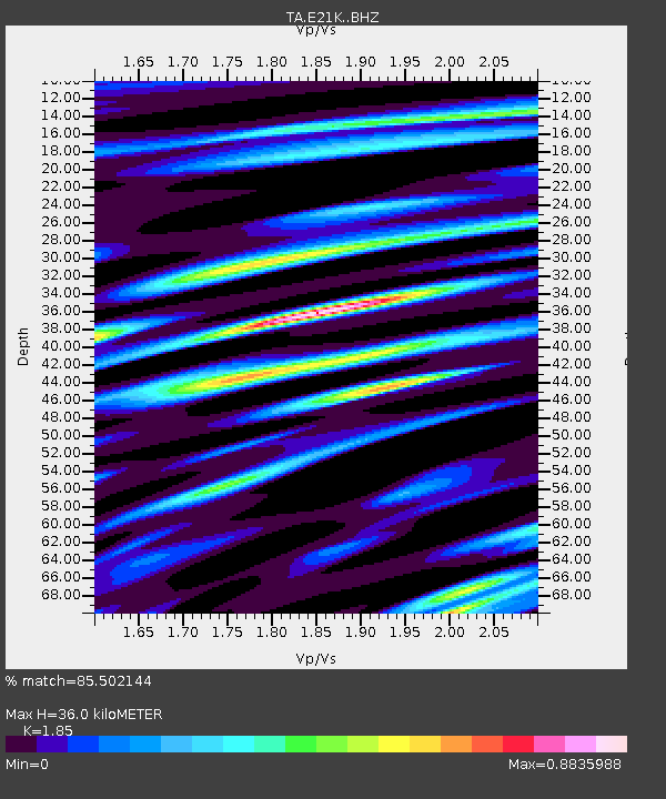
| Estimated Moho Depth: |
36.0 km |
| Estimated Crust Vp/Vs: |
1.85 |
| Assumed Crust Vp: |
6.221 km/s |
| Estimated Crust Vs: |
3.363 km/s |
| Estimated Crust Poisson's Ratio: |
0.29 |
|
| Radial Match: |
85.502144 % |
| Radial Bump: |
400 |
| Transverse Match: |
73.56269 % |
| Transverse Bump: |
400 |
| SOD ConfigId: |
21709731 |
| Insert Time: |
2020-07-05 19:35:00.004 +0000 |
| GWidth: |
2.5 |
| Max Bumps: |
400 |
| Tol: |
0.001 |
|

Signal To Noise
| Channel | StoN | STA | LTA |
| TA:E21K: :BHZ:20200621T19:15:14.374987Z | 7.331852 | 5.1353766E-7 | 7.0042006E-8 |
| TA:E21K: :BHN:20200621T19:15:14.374987Z | 4.2006235 | 1.7580585E-7 | 4.1852324E-8 |
| TA:E21K: :BHE:20200621T19:15:14.374987Z | 1.6806133 | 7.8112116E-8 | 4.6478338E-8 |
| Arrivals |
| Ps | 5.2 SECOND |
| PpPs | 16 SECOND |
| PsPs/PpSs | 21 SECOND |


