You are here: Home > Network List > TA - USArray Transportable Network (new EarthScope stations) Stations List
> Station F15K North Star Ditch, AK, USA > Earthquake Result Viewer
F15K North Star Ditch, AK, USA - Earthquake Result Viewer
| Earthquake location: |
Iceland Region |
| Earthquake latitude/longitude: |
66.4/-18.7 |
| Earthquake time(UTC): |
2020/06/21 (173) 19:07:55 GMT |
| Earthquake Depth: |
10 km |
| Earthquake Magnitude: |
6.0 mww |
| Earthquake Catalog/Contributor: |
NEIC PDE/us |
|
| Network: |
TA USArray Transportable Network (new EarthScope stations) |
| Station: |
F15K North Star Ditch, AK, USA |
| Lat/Lon: |
65.71 N/164.65 W |
| Elevation: |
388 m |
|
| Distance: |
46.0 deg |
| Az: |
341.206 deg |
| Baz: |
18.28 deg |
| Ray Param: |
0.070960246 |
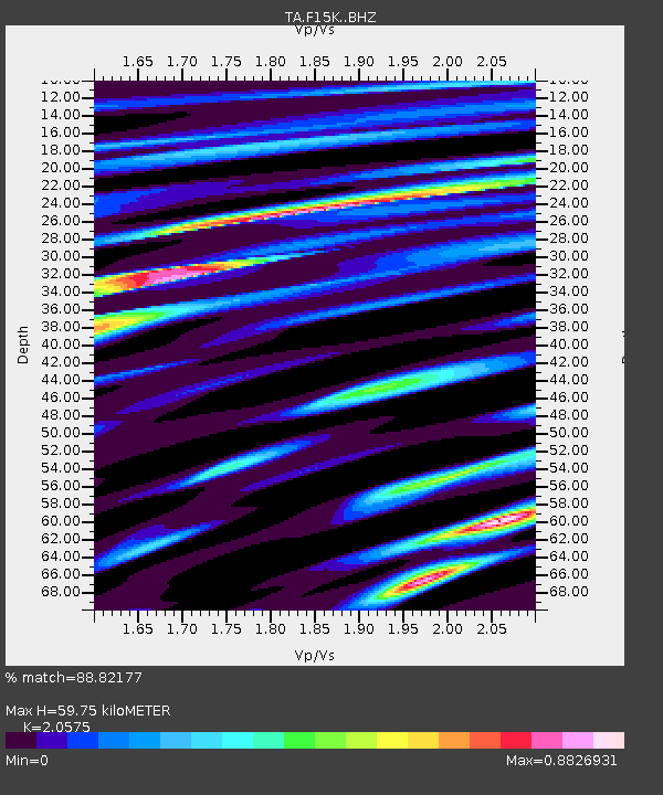
| Estimated Moho Depth: |
59.75 km |
| Estimated Crust Vp/Vs: |
2.06 |
| Assumed Crust Vp: |
6.276 km/s |
| Estimated Crust Vs: |
3.05 km/s |
| Estimated Crust Poisson's Ratio: |
0.35 |
|
| Radial Match: |
88.82177 % |
| Radial Bump: |
393 |
| Transverse Match: |
76.93831 % |
| Transverse Bump: |
400 |
| SOD ConfigId: |
21709731 |
| Insert Time: |
2020-07-05 19:35:14.077 +0000 |
| GWidth: |
2.5 |
| Max Bumps: |
400 |
| Tol: |
0.001 |
|

Signal To Noise
| Channel | StoN | STA | LTA |
| TA:F15K: :BHZ:20200621T19:15:47.175005Z | 3.2862725 | 2.1291925E-7 | 6.4790505E-8 |
| TA:F15K: :BHN:20200621T19:15:47.175005Z | 1.7482727 | 1.2177708E-7 | 6.9655655E-8 |
| TA:F15K: :BHE:20200621T19:15:47.175005Z | 1.251579 | 8.1516646E-8 | 6.513104E-8 |
| Arrivals |
| Ps | 11 SECOND |
| PpPs | 28 SECOND |
| PsPs/PpSs | 38 SECOND |


