You are here: Home > Network List > TA - USArray Transportable Network (new EarthScope stations) Stations List
> Station F24K Squaw Lake, AK, USA > Earthquake Result Viewer
F24K Squaw Lake, AK, USA - Earthquake Result Viewer
| Earthquake location: |
Iceland Region |
| Earthquake latitude/longitude: |
66.4/-18.7 |
| Earthquake time(UTC): |
2020/06/21 (173) 19:07:55 GMT |
| Earthquake Depth: |
10 km |
| Earthquake Magnitude: |
6.0 mww |
| Earthquake Catalog/Contributor: |
NEIC PDE/us |
|
| Network: |
TA USArray Transportable Network (new EarthScope stations) |
| Station: |
F24K Squaw Lake, AK, USA |
| Lat/Lon: |
67.52 N/147.89 W |
| Elevation: |
736 m |
|
| Distance: |
41.7 deg |
| Az: |
333.367 deg |
| Baz: |
28.002 deg |
| Ray Param: |
0.073647626 |
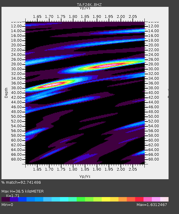
| Estimated Moho Depth: |
36.5 km |
| Estimated Crust Vp/Vs: |
1.71 |
| Assumed Crust Vp: |
6.522 km/s |
| Estimated Crust Vs: |
3.814 km/s |
| Estimated Crust Poisson's Ratio: |
0.24 |
|
| Radial Match: |
92.741486 % |
| Radial Bump: |
400 |
| Transverse Match: |
81.79707 % |
| Transverse Bump: |
400 |
| SOD ConfigId: |
21709731 |
| Insert Time: |
2020-07-05 19:35:24.253 +0000 |
| GWidth: |
2.5 |
| Max Bumps: |
400 |
| Tol: |
0.001 |
|
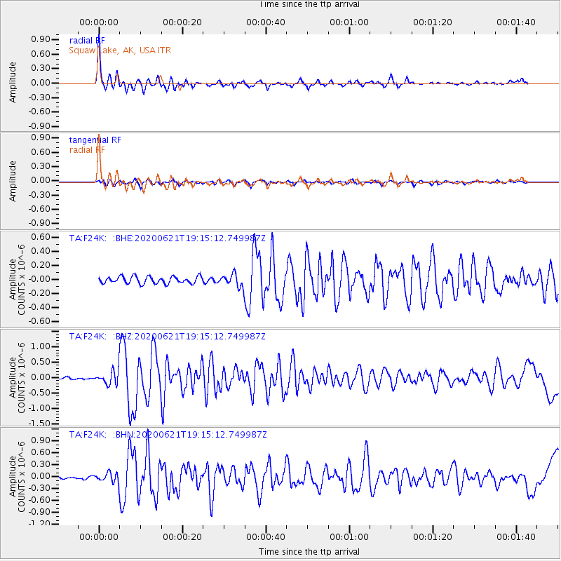
Signal To Noise
| Channel | StoN | STA | LTA |
| TA:F24K: :BHZ:20200621T19:15:12.749987Z | 4.8911963 | 2.2289811E-7 | 4.5571287E-8 |
| TA:F24K: :BHN:20200621T19:15:12.749987Z | 2.9030378 | 1.1927048E-7 | 4.1084718E-8 |
| TA:F24K: :BHE:20200621T19:15:12.749987Z | 1.8827089 | 9.208216E-8 | 4.89094E-8 |
| Arrivals |
| Ps | 4.3 SECOND |
| PpPs | 14 SECOND |
| PsPs/PpSs | 18 SECOND |


