You are here: Home > Network List > TA - USArray Transportable Network (new EarthScope stations) Stations List
> Station F26K Sheenjek River, AK, USA > Earthquake Result Viewer
F26K Sheenjek River, AK, USA - Earthquake Result Viewer
| Earthquake location: |
Iceland Region |
| Earthquake latitude/longitude: |
66.4/-18.7 |
| Earthquake time(UTC): |
2020/06/21 (173) 19:07:55 GMT |
| Earthquake Depth: |
10 km |
| Earthquake Magnitude: |
6.0 mww |
| Earthquake Catalog/Contributor: |
NEIC PDE/us |
|
| Network: |
TA USArray Transportable Network (new EarthScope stations) |
| Station: |
F26K Sheenjek River, AK, USA |
| Lat/Lon: |
67.69 N/144.15 W |
| Elevation: |
683 m |
|
| Distance: |
40.8 deg |
| Az: |
331.596 deg |
| Baz: |
30.127 deg |
| Ray Param: |
0.074177004 |
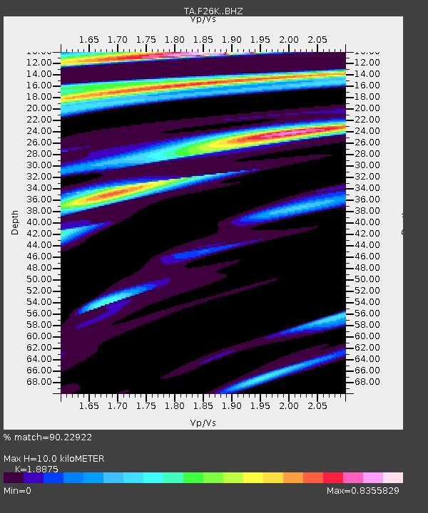
| Estimated Moho Depth: |
10.0 km |
| Estimated Crust Vp/Vs: |
1.89 |
| Assumed Crust Vp: |
6.522 km/s |
| Estimated Crust Vs: |
3.455 km/s |
| Estimated Crust Poisson's Ratio: |
0.30 |
|
| Radial Match: |
90.22922 % |
| Radial Bump: |
400 |
| Transverse Match: |
73.702515 % |
| Transverse Bump: |
400 |
| SOD ConfigId: |
21709731 |
| Insert Time: |
2020-07-05 19:35:27.071 +0000 |
| GWidth: |
2.5 |
| Max Bumps: |
400 |
| Tol: |
0.001 |
|
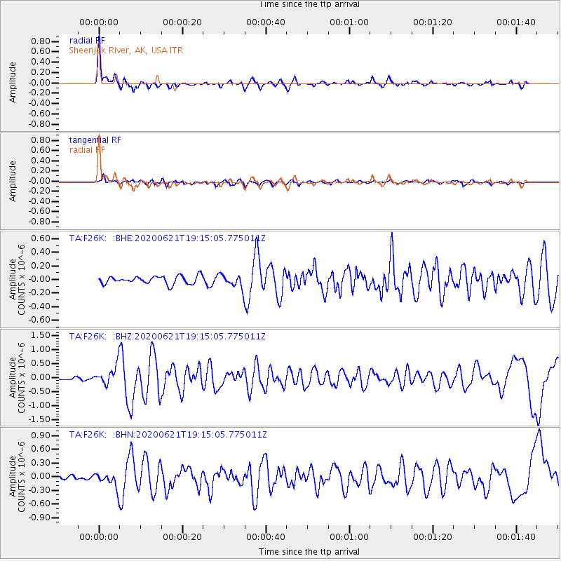
Signal To Noise
| Channel | StoN | STA | LTA |
| TA:F26K: :BHZ:20200621T19:15:05.775011Z | 5.4530354 | 3.5366435E-7 | 6.485642E-8 |
| TA:F26K: :BHN:20200621T19:15:05.775011Z | 4.885456 | 1.7521876E-7 | 3.5865384E-8 |
| TA:F26K: :BHE:20200621T19:15:05.775011Z | 1.7434549 | 1.0016091E-7 | 5.744967E-8 |
| Arrivals |
| Ps | 1.5 SECOND |
| PpPs | 4.1 SECOND |
| PsPs/PpSs | 5.6 SECOND |


