You are here: Home > Network List > TA - USArray Transportable Network (new EarthScope stations) Stations List
> Station I28M Miner Creek, YT, CAN > Earthquake Result Viewer
I28M Miner Creek, YT, CAN - Earthquake Result Viewer
| Earthquake location: |
Iceland Region |
| Earthquake latitude/longitude: |
66.4/-18.7 |
| Earthquake time(UTC): |
2020/06/21 (173) 19:07:55 GMT |
| Earthquake Depth: |
10 km |
| Earthquake Magnitude: |
6.0 mww |
| Earthquake Catalog/Contributor: |
NEIC PDE/us |
|
| Network: |
TA USArray Transportable Network (new EarthScope stations) |
| Station: |
I28M Miner Creek, YT, CAN |
| Lat/Lon: |
65.45 N/139.94 W |
| Elevation: |
1188 m |
|
| Distance: |
41.9 deg |
| Az: |
327.667 deg |
| Baz: |
31.037 deg |
| Ray Param: |
0.073498406 |
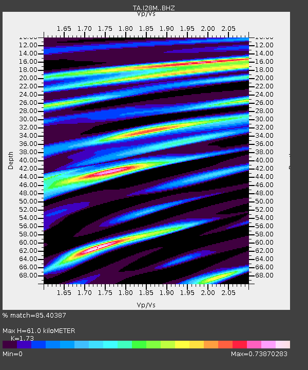
| Estimated Moho Depth: |
61.0 km |
| Estimated Crust Vp/Vs: |
1.73 |
| Assumed Crust Vp: |
6.566 km/s |
| Estimated Crust Vs: |
3.795 km/s |
| Estimated Crust Poisson's Ratio: |
0.25 |
|
| Radial Match: |
85.40387 % |
| Radial Bump: |
360 |
| Transverse Match: |
70.22518 % |
| Transverse Bump: |
400 |
| SOD ConfigId: |
21709731 |
| Insert Time: |
2020-07-05 19:36:06.514 +0000 |
| GWidth: |
2.5 |
| Max Bumps: |
400 |
| Tol: |
0.001 |
|

Signal To Noise
| Channel | StoN | STA | LTA |
| TA:I28M: :BHZ:20200621T19:15:14.675005Z | 8.163219 | 5.4422156E-7 | 6.666752E-8 |
| TA:I28M: :BHN:20200621T19:15:14.675005Z | 5.1686063 | 2.6040567E-7 | 5.0382187E-8 |
| TA:I28M: :BHE:20200621T19:15:14.675005Z | 4.201029 | 1.9241703E-7 | 4.580236E-8 |
| Arrivals |
| Ps | 7.3 SECOND |
| PpPs | 24 SECOND |
| PsPs/PpSs | 31 SECOND |


