You are here: Home > Network List > TD - TransAlta Monitoring Network Stations List
> Station TD011 Z > Earthquake Result Viewer
TD011 Z - Earthquake Result Viewer
| Earthquake location: |
Iceland Region |
| Earthquake latitude/longitude: |
66.4/-18.7 |
| Earthquake time(UTC): |
2020/06/21 (173) 19:07:55 GMT |
| Earthquake Depth: |
10 km |
| Earthquake Magnitude: |
6.0 mww |
| Earthquake Catalog/Contributor: |
NEIC PDE/us |
|
| Network: |
TD TransAlta Monitoring Network |
| Station: |
TD011 Z |
| Lat/Lon: |
52.55 N/115.52 W |
| Elevation: |
1103 m |
|
| Distance: |
45.9 deg |
| Az: |
302.443 deg |
| Baz: |
33.825 deg |
| Ray Param: |
0.07097692 |
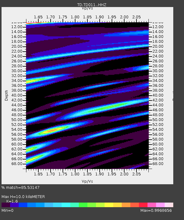
| Estimated Moho Depth: |
10.0 km |
| Estimated Crust Vp/Vs: |
1.60 |
| Assumed Crust Vp: |
6.426 km/s |
| Estimated Crust Vs: |
4.016 km/s |
| Estimated Crust Poisson's Ratio: |
0.18 |
|
| Radial Match: |
85.53147 % |
| Radial Bump: |
400 |
| Transverse Match: |
62.677296 % |
| Transverse Bump: |
400 |
| SOD ConfigId: |
21709731 |
| Insert Time: |
2020-07-05 19:37:16.732 +0000 |
| GWidth: |
2.5 |
| Max Bumps: |
400 |
| Tol: |
0.001 |
|

Signal To Noise
| Channel | StoN | STA | LTA |
| TD:TD011: :HHZ:20200621T19:15:46.939989Z | 3.892152 | 2.998371E-7 | 7.7036326E-8 |
| TD:TD011: :HH1:20200621T19:15:46.939989Z | 2.6169972 | 1.6503448E-7 | 6.306254E-8 |
| TD:TD011: :HH2:20200621T19:15:46.939989Z | 0.6716437 | 3.9101216E-8 | 5.8217204E-8 |
| Arrivals |
| Ps | 1.0 SECOND |
| PpPs | 3.8 SECOND |
| PsPs/PpSs | 4.8 SECOND |


