You are here: Home > Network List > TX - Texas Seismological Network Stations List
> Station PLPT Palo Pinto > Earthquake Result Viewer
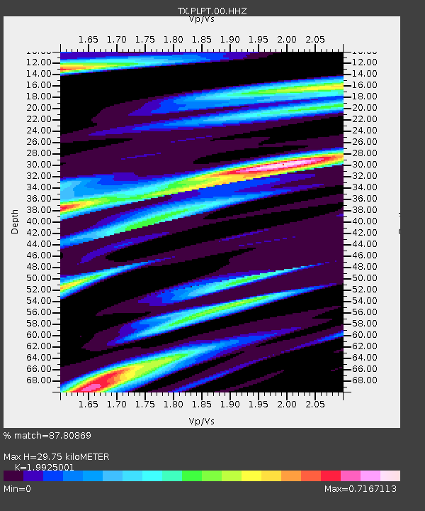
PLPT Palo Pinto - Earthquake Result Viewer
| Earthquake location: |
Iceland Region |
| Earthquake latitude/longitude: |
66.4/-18.7 |
| Earthquake time(UTC): |
2020/06/21 (173) 19:07:55 GMT |
| Earthquake Depth: |
10 km |
| Earthquake Magnitude: |
6.0 mww |
| Earthquake Catalog/Contributor: |
NEIC PDE/us |
|
| Network: |
TX Texas Seismological Network |
| Station: |
PLPT Palo Pinto |
| Lat/Lon: |
32.81 N/98.32 W |
| Elevation: |
336 m |
|
| Distance: |
56.3 deg |
| Az: |
275.412 deg |
| Baz: |
28.436 deg |
| Ray Param: |
0.06423365 |
| Estimated Moho Depth: |
29.75 km |
| Estimated Crust Vp/Vs: |
1.99 |
| Assumed Crust Vp: |
6.426 km/s |
| Estimated Crust Vs: |
3.225 km/s |
| Estimated Crust Poisson's Ratio: |
0.33 |
|
| Radial Match: |
87.80869 % |
| Radial Bump: |
286 |
| Transverse Match: |
75.32804 % |
| Transverse Bump: |
300 |
| SOD ConfigId: |
21709731 |
| Insert Time: |
2020-07-05 19:38:45.961 +0000 |
| GWidth: |
2.5 |
| Max Bumps: |
400 |
| Tol: |
0.001 |
|

Signal To Noise
| Channel | StoN | STA | LTA |
| TX:PLPT:00:HHZ:20200621T19:17:04.80501Z | 9.463081 | 5.3829723E-7 | 5.688393E-8 |
| TX:PLPT:00:HH1:20200621T19:17:04.80501Z | 4.269667 | 2.0491652E-7 | 4.799356E-8 |
| TX:PLPT:00:HH2:20200621T19:17:04.80501Z | 4.3670835 | 2.2510055E-7 | 5.1544827E-8 |
| Arrivals |
| Ps | 4.8 SECOND |
| PpPs | 13 SECOND |
| PsPs/PpSs | 18 SECOND |


