You are here: Home > Network List > TX - Texas Seismological Network Stations List
> Station RTBA Rita Blanca > Earthquake Result Viewer
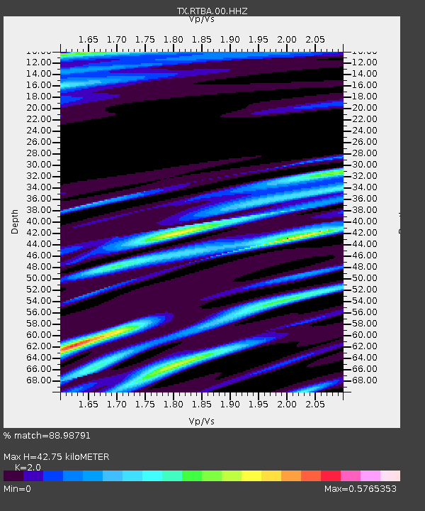
RTBA Rita Blanca - Earthquake Result Viewer
| Earthquake location: |
Iceland Region |
| Earthquake latitude/longitude: |
66.4/-18.7 |
| Earthquake time(UTC): |
2020/06/21 (173) 19:07:55 GMT |
| Earthquake Depth: |
10 km |
| Earthquake Magnitude: |
6.0 mww |
| Earthquake Catalog/Contributor: |
NEIC PDE/us |
|
| Network: |
TX Texas Seismological Network |
| Station: |
RTBA Rita Blanca |
| Lat/Lon: |
36.44 N/102.74 W |
| Elevation: |
1284 m |
|
| Distance: |
54.9 deg |
| Az: |
281.397 deg |
| Baz: |
29.317 deg |
| Ray Param: |
0.06515308 |
| Estimated Moho Depth: |
42.75 km |
| Estimated Crust Vp/Vs: |
2.00 |
| Assumed Crust Vp: |
6.306 km/s |
| Estimated Crust Vs: |
3.153 km/s |
| Estimated Crust Poisson's Ratio: |
0.33 |
|
| Radial Match: |
88.98791 % |
| Radial Bump: |
228 |
| Transverse Match: |
68.33565 % |
| Transverse Bump: |
400 |
| SOD ConfigId: |
21709731 |
| Insert Time: |
2020-07-05 19:38:48.518 +0000 |
| GWidth: |
2.5 |
| Max Bumps: |
400 |
| Tol: |
0.001 |
|

Signal To Noise
| Channel | StoN | STA | LTA |
| TX:RTBA:00:HHZ:20200621T19:16:54.724993Z | 8.56792 | 5.1848093E-7 | 6.051422E-8 |
| TX:RTBA:00:HH1:20200621T19:16:54.724993Z | 2.6318102 | 1.3990878E-7 | 5.3160665E-8 |
| TX:RTBA:00:HH2:20200621T19:16:54.724993Z | 3.773328 | 2.3826617E-7 | 6.314483E-8 |
| Arrivals |
| Ps | 7.1 SECOND |
| PpPs | 19 SECOND |
| PsPs/PpSs | 27 SECOND |


