You are here: Home > Network List > TX - Texas Seismological Network Stations List
> Station SNAG San Augustine > Earthquake Result Viewer
SNAG San Augustine - Earthquake Result Viewer
| Earthquake location: |
Iceland Region |
| Earthquake latitude/longitude: |
66.4/-18.7 |
| Earthquake time(UTC): |
2020/06/21 (173) 19:07:55 GMT |
| Earthquake Depth: |
10 km |
| Earthquake Magnitude: |
6.0 mww |
| Earthquake Catalog/Contributor: |
NEIC PDE/us |
|
| Network: |
TX Texas Seismological Network |
| Station: |
SNAG San Augustine |
| Lat/Lon: |
31.52 N/94.18 W |
| Elevation: |
84 m |
|
| Distance: |
55.8 deg |
| Az: |
270.95 deg |
| Baz: |
28.136 deg |
| Ray Param: |
0.064578205 |
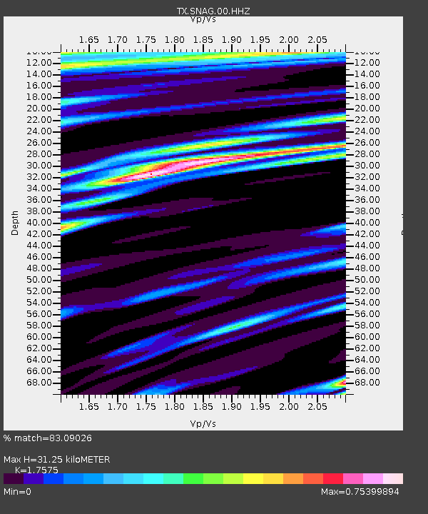
| Estimated Moho Depth: |
31.25 km |
| Estimated Crust Vp/Vs: |
1.76 |
| Assumed Crust Vp: |
5.738 km/s |
| Estimated Crust Vs: |
3.265 km/s |
| Estimated Crust Poisson's Ratio: |
0.26 |
|
| Radial Match: |
83.09026 % |
| Radial Bump: |
323 |
| Transverse Match: |
72.19251 % |
| Transverse Bump: |
332 |
| SOD ConfigId: |
21709731 |
| Insert Time: |
2020-07-05 19:38:57.698 +0000 |
| GWidth: |
2.5 |
| Max Bumps: |
400 |
| Tol: |
0.001 |
|

Signal To Noise
| Channel | StoN | STA | LTA |
| TX:SNAG:00:HHZ:20200621T19:17:01.045Z | 7.5364113 | 5.8106514E-7 | 7.710104E-8 |
| TX:SNAG:00:HH1:20200621T19:17:01.045Z | 2.6024678 | 2.2787033E-7 | 8.755933E-8 |
| TX:SNAG:00:HH2:20200621T19:17:01.045Z | 2.8967721 | 2.1560406E-7 | 7.4429074E-8 |
| Arrivals |
| Ps | 4.3 SECOND |
| PpPs | 14 SECOND |
| PsPs/PpSs | 19 SECOND |


