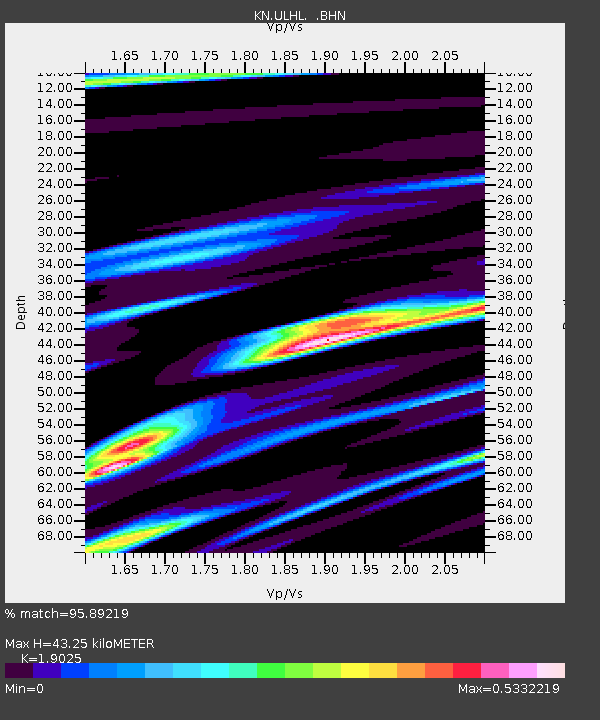
ULHL KN.ULHL - Earthquake Result Viewer
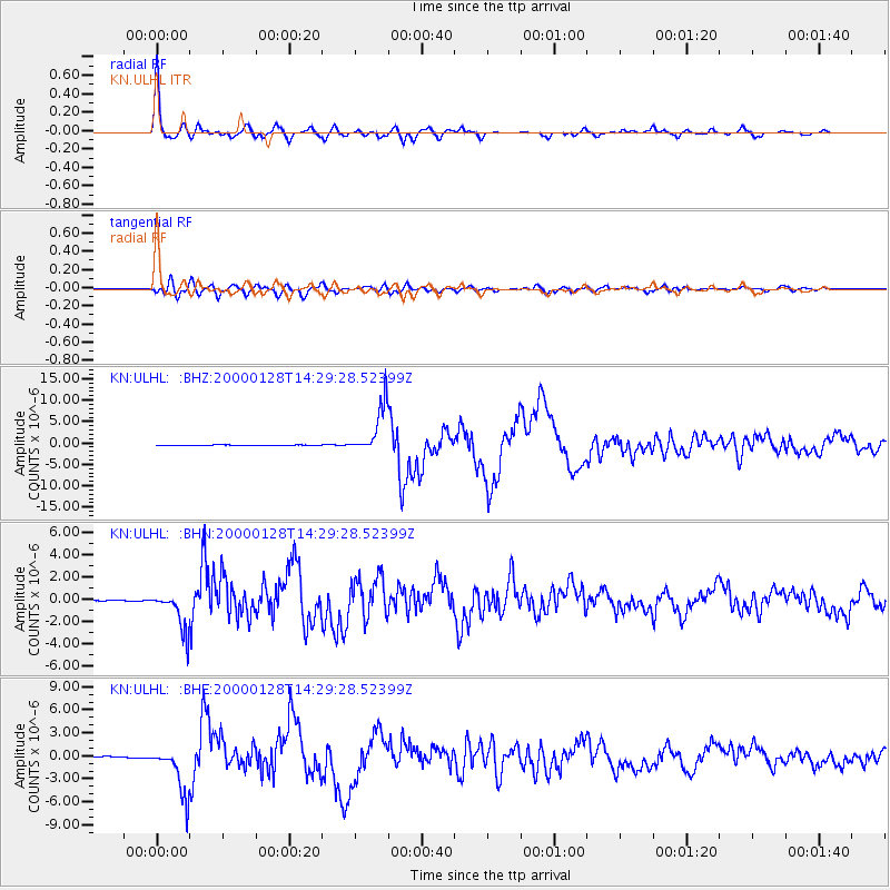
Earthquake location: Kuril Islands
Earthquake latitude/longitude: 43.0/146.8
Earthquake time(UTC): 2000/01/28 (028) 14:21:07 GMT
Earthquake Depth: 61 km
Earthquake Magnitude: 6.7 MB, 6.6 MS, 6.8 MW, 6.8 ME
Earthquake Catalog/Contributor: WHDF/NEIC
Network: KN Kyrgyz Seismic Telemetry Network
Station: ULHL KN.ULHL
Lat/Lon: 42.25 N/76.24 E
Elevation: 2040 m
Distance: 50.5 deg
Az: 294.777 deg
Baz: 63.691 deg
Ray Param: 0.06785587
Estimated Moho Depth: 43.25 km
Estimated Crust Vp/Vs: 1.90
Assumed Crust Vp: 6.306 km/s
Estimated Crust Vs: 3.315 km/s
Estimated Crust Poisson's Ratio: 0.31
Radial Match: 95.89219 %
Radial Bump: 337
Transverse Match: 85.96687 %
Transverse Bump: 400
SOD ConfigId: 3744
Insert Time: 2010-03-08 21:56:24.783 +0000
GWidth: 2.5
Max Bumps: 400
Tol: 0.001

Signal To Noise

ChannelStoNSTALTA
KN:ULHL: :BHN:20000128T14:29:28.52399Z33.4191471.7526571E-65.2444697E-8
KN:ULHL: :BHE:20000128T14:29:28.52399Z33.5850033.1189707E-69.286796E-8
KN:ULHL: :BHZ:20000128T14:29:28.52399Z112.324495.5922815E-64.978684E-8
Arrivals
Ps6.5 SECOND
PpPs19 SECOND
PsPs/PpSs25 SECOND