ULHL KN.ULHL - Earthquake Result Viewer
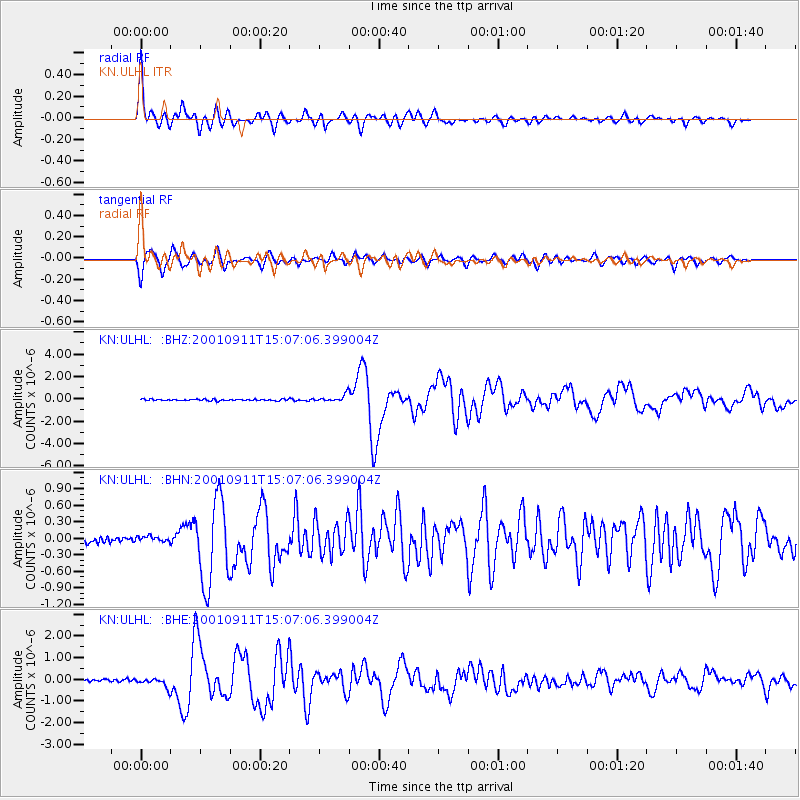
Earthquake location: Irian Jaya Region, Indonesia
Earthquake latitude/longitude: -0.6/133.1
Earthquake time(UTC): 2001/09/11 (254) 14:56:50 GMT
Earthquake Depth: 33 km
Earthquake Magnitude: 5.8 MB, 6.4 MS, 6.6 MW, 6.5 MW
Earthquake Catalog/Contributor: WHDF/NEIC
Network: KN Kyrgyz Seismic Telemetry Network
Station: ULHL KN.ULHL
Lat/Lon: 42.25 N/76.24 E
Elevation: 2040 m
Distance: 66.5 deg
Az: 317.295 deg
Baz: 114.024 deg
Ray Param: 0.057528295
Estimated Moho Depth: 56.25 km
Estimated Crust Vp/Vs: 1.78
Assumed Crust Vp: 6.306 km/s
Estimated Crust Vs: 3.548 km/s
Estimated Crust Poisson's Ratio: 0.27
Radial Match: 95.63691 %
Radial Bump: 372
Transverse Match: 89.25374 %
Transverse Bump: 400
SOD ConfigId: 20082
Insert Time: 2010-03-08 21:57:08.677 +0000
GWidth: 2.5
Max Bumps: 400
Tol: 0.001

Signal To Noise

ChannelStoNSTALTA
KN:ULHL: :BHN:20010911T15:07:06.399004Z0.785807554.1247006E-85.2489955E-8
KN:ULHL: :BHE:20010911T15:07:06.399004Z4.3656142.0609195E-74.720801E-8
KN:ULHL: :BHZ:20010911T15:07:06.399004Z4.77738953.228042E-76.756916E-8
Arrivals
Ps7.2 SECOND
PpPs24 SECOND
PsPs/PpSs31 SECOND