You are here: Home > Network List > US - United States National Seismic Network Stations List
> Station MNTX Cornudas Mountains, Texas, USA > Earthquake Result Viewer
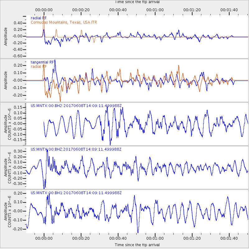
MNTX Cornudas Mountains, Texas, USA - Earthquake Result Viewer
*The percent match for this event was below the threshold and hence no stack was calculated.
| Earthquake location: |
Northern Peru |
| Earthquake latitude/longitude: |
-8.0/-75.9 |
| Earthquake time(UTC): |
2017/06/08 (159) 14:01:09 GMT |
| Earthquake Depth: |
108 km |
| Earthquake Magnitude: |
5.2 Mww |
| Earthquake Catalog/Contributor: |
NEIC PDE/us |
|
| Network: |
US United States National Seismic Network |
| Station: |
MNTX Cornudas Mountains, Texas, USA |
| Lat/Lon: |
31.70 N/105.38 W |
| Elevation: |
404 m |
|
| Distance: |
48.5 deg |
| Az: |
325.899 deg |
| Baz: |
139.35 deg |
| Ray Param: |
$rayparam |
*The percent match for this event was below the threshold and hence was not used in the summary stack. |
|
| Radial Match: |
58.621307 % |
| Radial Bump: |
400 |
| Transverse Match: |
61.26064 % |
| Transverse Bump: |
400 |
| SOD ConfigId: |
2140511 |
| Insert Time: |
2017-07-02 15:46:00.438 +0000 |
| GWidth: |
2.5 |
| Max Bumps: |
400 |
| Tol: |
0.001 |
|
Signal To Noise
| Channel | StoN | STA | LTA |
| US:MNTX:00:BHZ:20170608T14:09:11.499988Z | 2.014571 | 2.0701975E-7 | 1.0276121E-7 |
| US:MNTX:00:BH1:20170608T14:09:11.499988Z | 1.2217414 | 1.0720006E-7 | 8.774365E-8 |
| US:MNTX:00:BH2:20170608T14:09:11.499988Z | 1.4282848 | 9.4035194E-8 | 6.5837845E-8 |
| Arrivals |
| Ps | |
| PpPs | |
| PsPs/PpSs | |


