You are here: Home > Network List > AV - Alaska Volcano Observatory Stations List
> Station AMKA Regional Station, Amchitka Island, Alaska > Earthquake Result Viewer
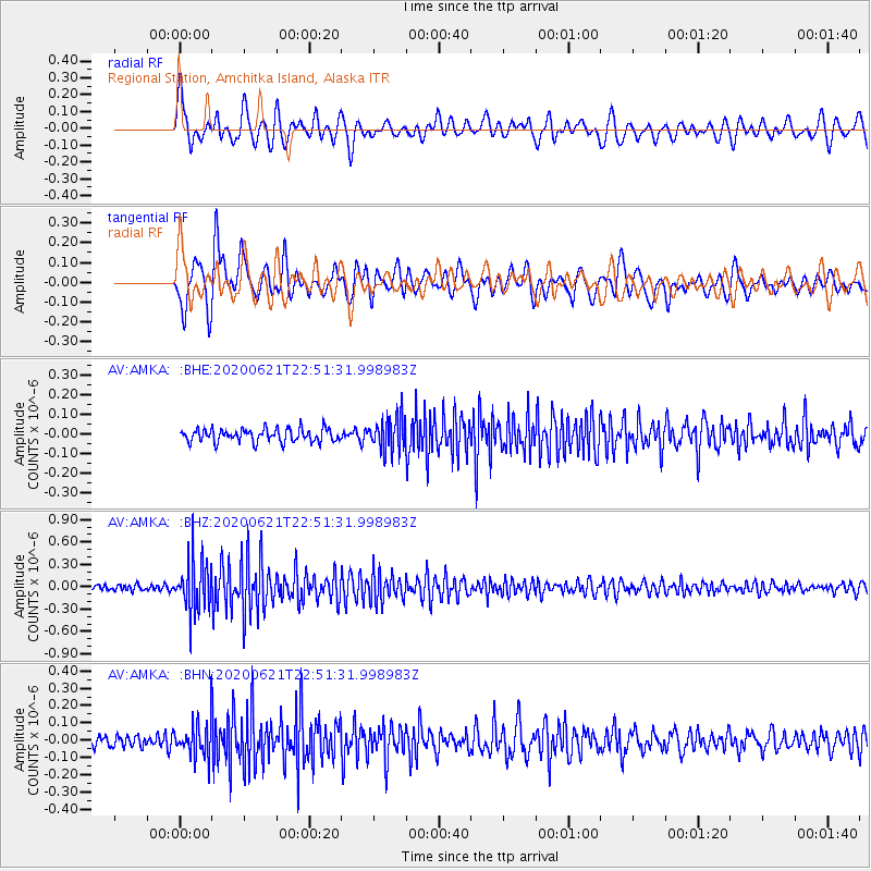
AMKA Regional Station, Amchitka Island, Alaska - Earthquake Result Viewer
*The percent match for this event was below the threshold and hence no stack was calculated.
| Earthquake location: |
Myanmar-India Border Region |
| Earthquake latitude/longitude: |
23.1/93.3 |
| Earthquake time(UTC): |
2020/06/21 (173) 22:40:52 GMT |
| Earthquake Depth: |
13 km |
| Earthquake Magnitude: |
5.6 Mww |
| Earthquake Catalog/Contributor: |
NEIC PDE/us |
|
| Network: |
AV Alaska Volcano Observatory |
| Station: |
AMKA Regional Station, Amchitka Island, Alaska |
| Lat/Lon: |
51.38 N/179.30 E |
| Elevation: |
116 m |
|
| Distance: |
69.9 deg |
| Az: |
41.754 deg |
| Baz: |
281.996 deg |
| Ray Param: |
$rayparam |
*The percent match for this event was below the threshold and hence was not used in the summary stack. |
|
| Radial Match: |
69.63265 % |
| Radial Bump: |
400 |
| Transverse Match: |
68.648575 % |
| Transverse Bump: |
400 |
| SOD ConfigId: |
21709731 |
| Insert Time: |
2020-07-05 22:44:15.193 +0000 |
| GWidth: |
2.5 |
| Max Bumps: |
400 |
| Tol: |
0.001 |
|
Signal To Noise
| Channel | StoN | STA | LTA |
| AV:AMKA: :BHZ:20200621T22:51:31.998983Z | 9.7401705 | 3.4774095E-7 | 3.570173E-8 |
| AV:AMKA: :BHN:20200621T22:51:31.998983Z | 3.1682615 | 1.1006228E-7 | 3.4739013E-8 |
| AV:AMKA: :BHE:20200621T22:51:31.998983Z | 2.5265455 | 8.413053E-8 | 3.329864E-8 |
| Arrivals |
| Ps | |
| PpPs | |
| PsPs/PpSs | |


