ULHL KN.ULHL - Earthquake Result Viewer
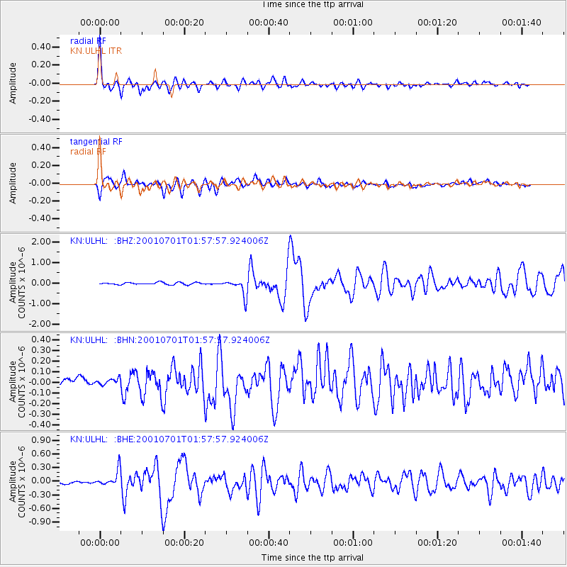
Earthquake location: New Britain Region, P.N.G.
Earthquake latitude/longitude: -4.3/153.0
Earthquake time(UTC): 2001/07/01 (182) 01:46:06 GMT
Earthquake Depth: 28 km
Earthquake Magnitude: 5.8 MB, 6.0 MS, 6.1 MW, 6.0 ME
Earthquake Catalog/Contributor: WHDF/NEIC
Network: KN Kyrgyz Seismic Telemetry Network
Station: ULHL KN.ULHL
Lat/Lon: 42.25 N/76.24 E
Elevation: 2040 m
Distance: 83.1 deg
Az: 313.288 deg
Baz: 102.151 deg
Ray Param: 0.046393488
Estimated Moho Depth: 64.25 km
Estimated Crust Vp/Vs: 1.64
Assumed Crust Vp: 6.306 km/s
Estimated Crust Vs: 3.839 km/s
Estimated Crust Poisson's Ratio: 0.21
Radial Match: 94.28845 %
Radial Bump: 400
Transverse Match: 80.40889 %
Transverse Bump: 400
SOD ConfigId: 4714
Insert Time: 2010-03-08 21:57:57.452 +0000
GWidth: 2.5
Max Bumps: 400
Tol: 0.001

Signal To Noise

ChannelStoNSTALTA
KN:ULHL: :BHN:20010701T01:57:57.924006Z1.22245963.1222886E-82.5541038E-8
KN:ULHL: :BHE:20010701T01:57:57.924006Z6.0385231.90059E-73.1474418E-8
KN:ULHL: :BHZ:20010701T01:57:57.924006Z8.2791324.201241E-75.0744948E-8
Arrivals
Ps6.7 SECOND
PpPs26 SECOND
PsPs/PpSs33 SECOND