You are here: Home > Network List > TA - USArray Transportable Network (new EarthScope stations) Stations List
> Station D23K Nanushuk River, AK USA > Earthquake Result Viewer
D23K Nanushuk River, AK USA - Earthquake Result Viewer
| Earthquake location: |
Myanmar-India Border Region |
| Earthquake latitude/longitude: |
23.1/93.3 |
| Earthquake time(UTC): |
2020/06/21 (173) 22:40:52 GMT |
| Earthquake Depth: |
13 km |
| Earthquake Magnitude: |
5.6 Mww |
| Earthquake Catalog/Contributor: |
NEIC PDE/us |
|
| Network: |
TA USArray Transportable Network (new EarthScope stations) |
| Station: |
D23K Nanushuk River, AK USA |
| Lat/Lon: |
68.97 N/150.68 W |
| Elevation: |
406 m |
|
| Distance: |
77.4 deg |
| Az: |
19.412 deg |
| Baz: |
302.061 deg |
| Ray Param: |
0.05034743 |
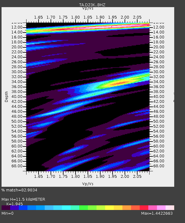
| Estimated Moho Depth: |
11.5 km |
| Estimated Crust Vp/Vs: |
1.95 |
| Assumed Crust Vp: |
6.221 km/s |
| Estimated Crust Vs: |
3.198 km/s |
| Estimated Crust Poisson's Ratio: |
0.32 |
|
| Radial Match: |
82.9834 % |
| Radial Bump: |
400 |
| Transverse Match: |
68.53461 % |
| Transverse Bump: |
400 |
| SOD ConfigId: |
21709731 |
| Insert Time: |
2020-07-05 22:50:01.400 +0000 |
| GWidth: |
2.5 |
| Max Bumps: |
400 |
| Tol: |
0.001 |
|
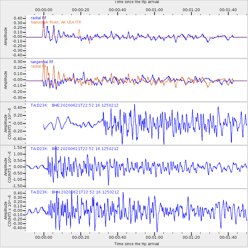
Signal To Noise
| Channel | StoN | STA | LTA |
| TA:D23K: :BHZ:20200621T22:52:16.125021Z | 3.5699322 | 3.3268972E-7 | 9.319216E-8 |
| TA:D23K: :BHN:20200621T22:52:16.125021Z | 1.9744555 | 8.949514E-8 | 4.532649E-8 |
| TA:D23K: :BHE:20200621T22:52:16.125021Z | 1.3831718 | 1.0863695E-7 | 7.85419E-8 |
| Arrivals |
| Ps | 1.8 SECOND |
| PpPs | 5.3 SECOND |
| PsPs/PpSs | 7.1 SECOND |


