You are here: Home > Network List > TA - USArray Transportable Network (new EarthScope stations) Stations List
> Station D27M Malcolm River, YT, CAN > Earthquake Result Viewer
D27M Malcolm River, YT, CAN - Earthquake Result Viewer
| Earthquake location: |
Myanmar-India Border Region |
| Earthquake latitude/longitude: |
23.1/93.3 |
| Earthquake time(UTC): |
2020/06/21 (173) 22:40:52 GMT |
| Earthquake Depth: |
13 km |
| Earthquake Magnitude: |
5.6 Mww |
| Earthquake Catalog/Contributor: |
NEIC PDE/us |
|
| Network: |
TA USArray Transportable Network (new EarthScope stations) |
| Station: |
D27M Malcolm River, YT, CAN |
| Lat/Lon: |
69.24 N/140.96 W |
| Elevation: |
896 m |
|
| Distance: |
80.0 deg |
| Az: |
17.079 deg |
| Baz: |
310.676 deg |
| Ray Param: |
0.04855514 |
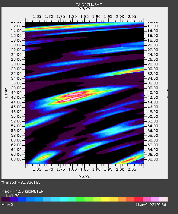
| Estimated Moho Depth: |
42.5 km |
| Estimated Crust Vp/Vs: |
1.79 |
| Assumed Crust Vp: |
6.522 km/s |
| Estimated Crust Vs: |
3.643 km/s |
| Estimated Crust Poisson's Ratio: |
0.27 |
|
| Radial Match: |
81.830185 % |
| Radial Bump: |
400 |
| Transverse Match: |
70.177 % |
| Transverse Bump: |
400 |
| SOD ConfigId: |
21709731 |
| Insert Time: |
2020-07-05 22:50:04.266 +0000 |
| GWidth: |
2.5 |
| Max Bumps: |
400 |
| Tol: |
0.001 |
|

Signal To Noise
| Channel | StoN | STA | LTA |
| TA:D27M: :BHZ:20200621T22:52:30.599997Z | 2.0713239 | 1.1133177E-7 | 5.374909E-8 |
| TA:D27M: :BHN:20200621T22:52:30.599997Z | 0.6848228 | 3.0234883E-8 | 4.4149935E-8 |
| TA:D27M: :BHE:20200621T22:52:30.599997Z | 0.6655863 | 2.6059304E-8 | 3.9152404E-8 |
| Arrivals |
| Ps | 5.3 SECOND |
| PpPs | 18 SECOND |
| PsPs/PpSs | 23 SECOND |


