You are here: Home > Network List > TA - USArray Transportable Network (new EarthScope stations) Stations List
> Station F31M Tsiigehtchic, NWT, CAN > Earthquake Result Viewer
F31M Tsiigehtchic, NWT, CAN - Earthquake Result Viewer
| Earthquake location: |
Myanmar-India Border Region |
| Earthquake latitude/longitude: |
23.1/93.3 |
| Earthquake time(UTC): |
2020/06/21 (173) 22:40:52 GMT |
| Earthquake Depth: |
13 km |
| Earthquake Magnitude: |
5.6 Mww |
| Earthquake Catalog/Contributor: |
NEIC PDE/us |
|
| Network: |
TA USArray Transportable Network (new EarthScope stations) |
| Station: |
F31M Tsiigehtchic, NWT, CAN |
| Lat/Lon: |
67.44 N/133.74 W |
| Elevation: |
56 m |
|
| Distance: |
83.2 deg |
| Az: |
16.512 deg |
| Baz: |
317.302 deg |
| Ray Param: |
0.046341702 |
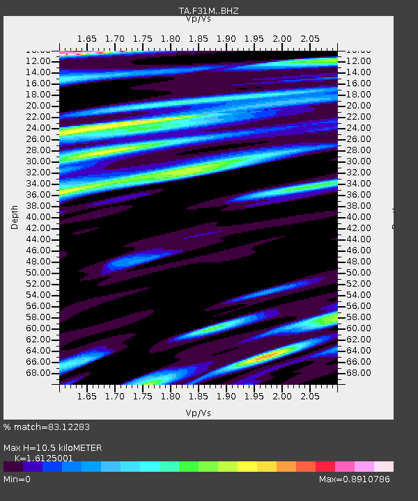
| Estimated Moho Depth: |
10.5 km |
| Estimated Crust Vp/Vs: |
1.61 |
| Assumed Crust Vp: |
6.171 km/s |
| Estimated Crust Vs: |
3.827 km/s |
| Estimated Crust Poisson's Ratio: |
0.19 |
|
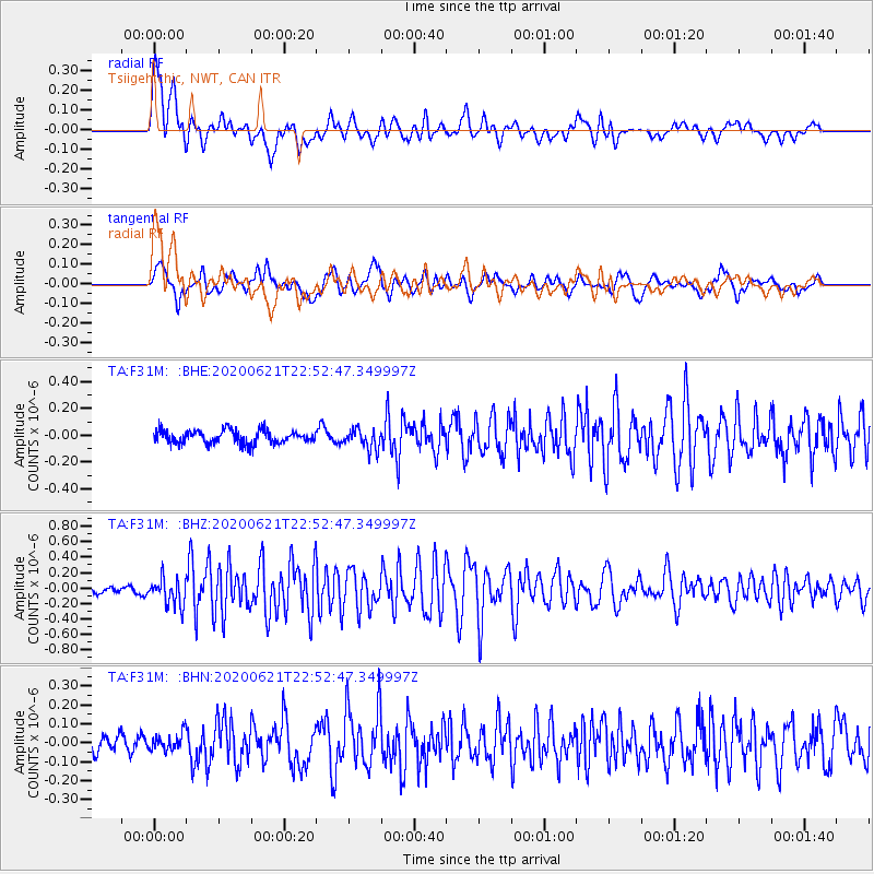
| Radial Match: |
83.12283 % |
| Radial Bump: |
400 |
| Transverse Match: |
61.101967 % |
| Transverse Bump: |
400 |
| SOD ConfigId: |
21709731 |
| Insert Time: |
2020-07-05 22:50:36.096 +0000 |
| GWidth: |
2.5 |
| Max Bumps: |
400 |
| Tol: |
0.001 |
|
Signal To Noise
| Channel | StoN | STA | LTA |
| TA:F31M: :BHZ:20200621T22:52:47.349997Z | 2.404444 | 1.699416E-7 | 7.0678134E-8 |
| TA:F31M: :BHN:20200621T22:52:47.349997Z | 0.7057617 | 4.556896E-8 | 6.456707E-8 |
| TA:F31M: :BHE:20200621T22:52:47.349997Z | 1.4759141 | 7.316361E-8 | 4.9571725E-8 |
| Arrivals |
| Ps | 1.1 SECOND |
| PpPs | 4.3 SECOND |
| PsPs/PpSs | 5.4 SECOND |


