You are here: Home > Network List > TA - USArray Transportable Network (new EarthScope stations) Stations List
> Station H31M Peel River, Yukon, CAN > Earthquake Result Viewer
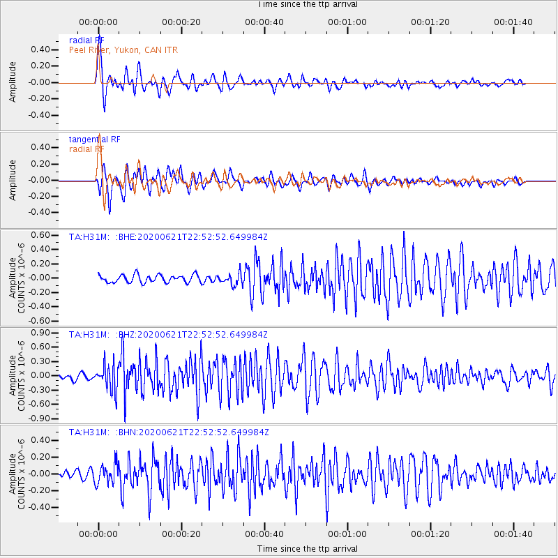
H31M Peel River, Yukon, CAN - Earthquake Result Viewer
*The percent match for this event was below the threshold and hence no stack was calculated.
| Earthquake location: |
Myanmar-India Border Region |
| Earthquake latitude/longitude: |
23.1/93.3 |
| Earthquake time(UTC): |
2020/06/21 (173) 22:40:52 GMT |
| Earthquake Depth: |
13 km |
| Earthquake Magnitude: |
5.6 Mww |
| Earthquake Catalog/Contributor: |
NEIC PDE/us |
|
| Network: |
TA USArray Transportable Network (new EarthScope stations) |
| Station: |
H31M Peel River, Yukon, CAN |
| Lat/Lon: |
65.81 N/134.34 W |
| Elevation: |
642 m |
|
| Distance: |
84.3 deg |
| Az: |
17.814 deg |
| Baz: |
316.894 deg |
| Ray Param: |
$rayparam |
*The percent match for this event was below the threshold and hence was not used in the summary stack. |
|
| Radial Match: |
79.63605 % |
| Radial Bump: |
400 |
| Transverse Match: |
84.909676 % |
| Transverse Bump: |
400 |
| SOD ConfigId: |
21709731 |
| Insert Time: |
2020-07-05 22:51:00.061 +0000 |
| GWidth: |
2.5 |
| Max Bumps: |
400 |
| Tol: |
0.001 |
|
Signal To Noise
| Channel | StoN | STA | LTA |
| TA:H31M: :BHZ:20200621T22:52:52.649984Z | 4.018829 | 2.673605E-7 | 6.652697E-8 |
| TA:H31M: :BHN:20200621T22:52:52.649984Z | 1.430326 | 1.1951678E-7 | 8.3559115E-8 |
| TA:H31M: :BHE:20200621T22:52:52.649984Z | 1.4918778 | 7.936339E-8 | 5.3196977E-8 |
| Arrivals |
| Ps | |
| PpPs | |
| PsPs/PpSs | |


