You are here: Home > Network List > TA - USArray Transportable Network (new EarthScope stations) Stations List
> Station I30M Mount Dempster, Yukon, CAN > Earthquake Result Viewer
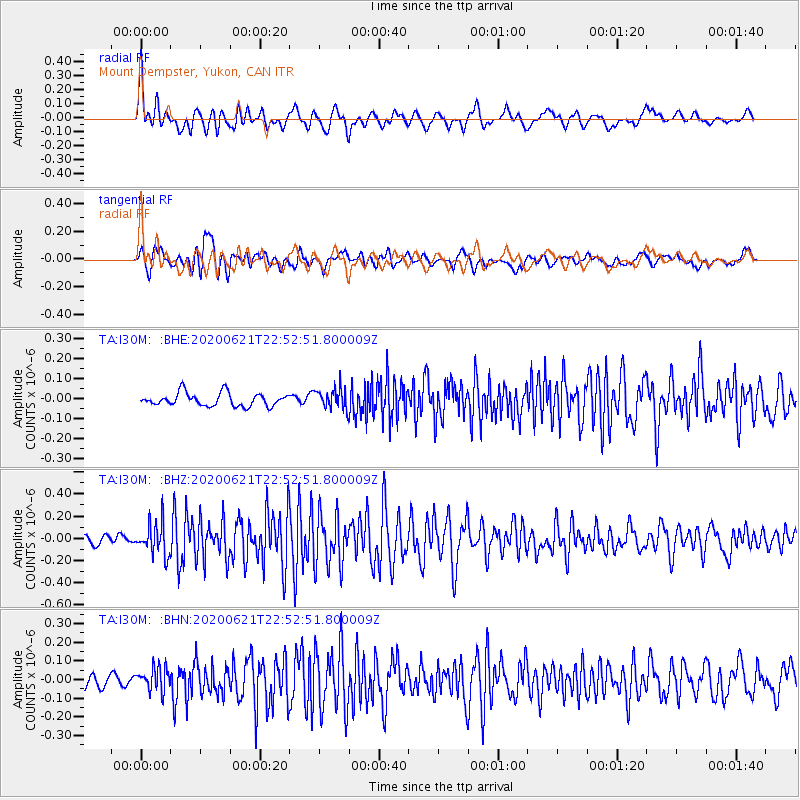
I30M Mount Dempster, Yukon, CAN - Earthquake Result Viewer
*The percent match for this event was below the threshold and hence no stack was calculated.
| Earthquake location: |
Myanmar-India Border Region |
| Earthquake latitude/longitude: |
23.1/93.3 |
| Earthquake time(UTC): |
2020/06/21 (173) 22:40:52 GMT |
| Earthquake Depth: |
13 km |
| Earthquake Magnitude: |
5.6 Mww |
| Earthquake Catalog/Contributor: |
NEIC PDE/us |
|
| Network: |
TA USArray Transportable Network (new EarthScope stations) |
| Station: |
I30M Mount Dempster, Yukon, CAN |
| Lat/Lon: |
65.22 N/136.38 W |
| Elevation: |
1399 m |
|
| Distance: |
84.1 deg |
| Az: |
18.836 deg |
| Baz: |
315.148 deg |
| Ray Param: |
$rayparam |
*The percent match for this event was below the threshold and hence was not used in the summary stack. |
|
| Radial Match: |
70.12539 % |
| Radial Bump: |
400 |
| Transverse Match: |
64.33247 % |
| Transverse Bump: |
400 |
| SOD ConfigId: |
21709731 |
| Insert Time: |
2020-07-05 22:51:04.648 +0000 |
| GWidth: |
2.5 |
| Max Bumps: |
400 |
| Tol: |
0.001 |
|
Signal To Noise
| Channel | StoN | STA | LTA |
| TA:I30M: :BHZ:20200621T22:52:51.800009Z | 3.162774 | 1.4393085E-7 | 4.5507786E-8 |
| TA:I30M: :BHN:20200621T22:52:51.800009Z | 2.023852 | 6.3575875E-8 | 3.14133E-8 |
| TA:I30M: :BHE:20200621T22:52:51.800009Z | 1.5745728 | 5.178668E-8 | 3.2889353E-8 |
| Arrivals |
| Ps | |
| PpPs | |
| PsPs/PpSs | |


