You are here: Home > Network List > AV - Alaska Volcano Observatory Stations List
> Station ACH Angle Creek Headwaters, Katmai, Alaska > Earthquake Result Viewer
ACH Angle Creek Headwaters, Katmai, Alaska - Earthquake Result Viewer
| Earthquake location: |
Minahassa Peninsula, Sulawesi |
| Earthquake latitude/longitude: |
0.1/123.8 |
| Earthquake time(UTC): |
2020/06/23 (175) 07:43:28 GMT |
| Earthquake Depth: |
102 km |
| Earthquake Magnitude: |
5.9 mww |
| Earthquake Catalog/Contributor: |
NEIC PDE/us |
|
| Network: |
AV Alaska Volcano Observatory |
| Station: |
ACH Angle Creek Headwaters, Katmai, Alaska |
| Lat/Lon: |
58.21 N/155.33 W |
| Elevation: |
960 m |
|
| Distance: |
85.1 deg |
| Az: |
31.638 deg |
| Baz: |
262.27 deg |
| Ray Param: |
0.044763785 |
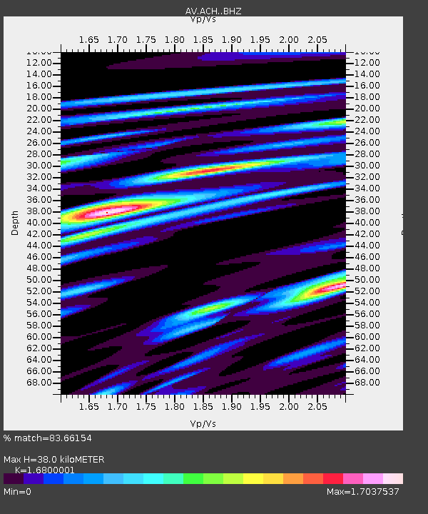
| Estimated Moho Depth: |
38.0 km |
| Estimated Crust Vp/Vs: |
1.68 |
| Assumed Crust Vp: |
6.438 km/s |
| Estimated Crust Vs: |
3.832 km/s |
| Estimated Crust Poisson's Ratio: |
0.23 |
|
| Radial Match: |
83.66154 % |
| Radial Bump: |
328 |
| Transverse Match: |
82.04384 % |
| Transverse Bump: |
391 |
| SOD ConfigId: |
21709731 |
| Insert Time: |
2020-07-07 07:47:48.240 +0000 |
| GWidth: |
2.5 |
| Max Bumps: |
400 |
| Tol: |
0.001 |
|

Signal To Noise
| Channel | StoN | STA | LTA |
| AV:ACH: :BHZ:20200623T07:55:22.207974Z | 20.24815 | 1.2232284E-6 | 6.0411864E-8 |
| AV:ACH: :BHN:20200623T07:55:22.207974Z | 9.963059 | 5.774656E-7 | 5.796067E-8 |
| AV:ACH: :BHE:20200623T07:55:22.207974Z | 18.638597 | 1.125289E-6 | 6.037413E-8 |
| Arrivals |
| Ps | 4.1 SECOND |
| PpPs | 15 SECOND |
| PsPs/PpSs | 20 SECOND |


