You are here: Home > Network List > AV - Alaska Volcano Observatory Stations List
> Station AMKA Regional Station, Amchitka Island, Alaska > Earthquake Result Viewer
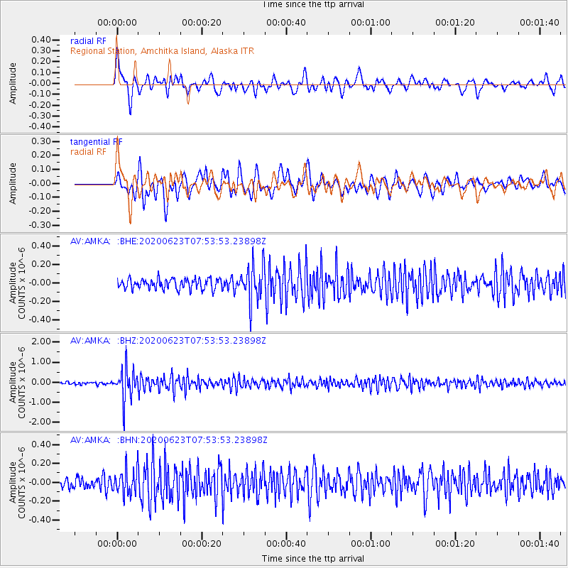
AMKA Regional Station, Amchitka Island, Alaska - Earthquake Result Viewer
*The percent match for this event was below the threshold and hence no stack was calculated.
| Earthquake location: |
Minahassa Peninsula, Sulawesi |
| Earthquake latitude/longitude: |
0.1/123.8 |
| Earthquake time(UTC): |
2020/06/23 (175) 07:43:28 GMT |
| Earthquake Depth: |
102 km |
| Earthquake Magnitude: |
5.9 mww |
| Earthquake Catalog/Contributor: |
NEIC PDE/us |
|
| Network: |
AV Alaska Volcano Observatory |
| Station: |
AMKA Regional Station, Amchitka Island, Alaska |
| Lat/Lon: |
51.38 N/179.30 E |
| Elevation: |
116 m |
|
| Distance: |
69.2 deg |
| Az: |
33.551 deg |
| Baz: |
241.866 deg |
| Ray Param: |
$rayparam |
*The percent match for this event was below the threshold and hence was not used in the summary stack. |
|
| Radial Match: |
70.35989 % |
| Radial Bump: |
400 |
| Transverse Match: |
73.15888 % |
| Transverse Bump: |
400 |
| SOD ConfigId: |
21709731 |
| Insert Time: |
2020-07-07 07:48:02.948 +0000 |
| GWidth: |
2.5 |
| Max Bumps: |
400 |
| Tol: |
0.001 |
|
Signal To Noise
| Channel | StoN | STA | LTA |
| AV:AMKA: :BHZ:20200623T07:53:53.23898Z | 14.694581 | 7.659547E-7 | 5.212498E-8 |
| AV:AMKA: :BHN:20200623T07:53:53.23898Z | 2.7530234 | 1.3802044E-7 | 5.0134133E-8 |
| AV:AMKA: :BHE:20200623T07:53:53.23898Z | 3.6767337 | 2.0302066E-7 | 5.521767E-8 |
| Arrivals |
| Ps | |
| PpPs | |
| PsPs/PpSs | |


