You are here: Home > Network List > TA - USArray Transportable Network (new EarthScope stations) Stations List
> Station A22K Sinclair Lake, AK, USA > Earthquake Result Viewer
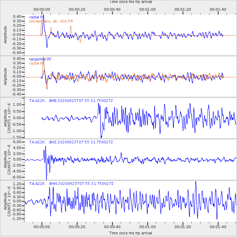
A22K Sinclair Lake, AK, USA - Earthquake Result Viewer
| Earthquake location: |
Minahassa Peninsula, Sulawesi |
| Earthquake latitude/longitude: |
0.1/123.8 |
| Earthquake time(UTC): |
2020/06/23 (175) 07:43:28 GMT |
| Earthquake Depth: |
102 km |
| Earthquake Magnitude: |
5.9 mww |
| Earthquake Catalog/Contributor: |
NEIC PDE/us |
|
| Network: |
TA USArray Transportable Network (new EarthScope stations) |
| Station: |
A22K Sinclair Lake, AK, USA |
| Lat/Lon: |
71.00 N/154.97 W |
| Elevation: |
6.0 m |
|
| Distance: |
87.1 deg |
| Az: |
18.909 deg |
| Baz: |
261.724 deg |
| Ray Param: |
0.043367397 |
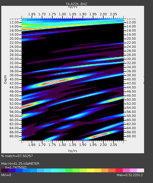
| Estimated Moho Depth: |
41.25 km |
| Estimated Crust Vp/Vs: |
1.75 |
| Assumed Crust Vp: |
5.782 km/s |
| Estimated Crust Vs: |
3.309 km/s |
| Estimated Crust Poisson's Ratio: |
0.26 |
|
| Radial Match: |
87.50257 % |
| Radial Bump: |
400 |
| Transverse Match: |
79.04298 % |
| Transverse Bump: |
400 |
| SOD ConfigId: |
21709731 |
| Insert Time: |
2020-07-07 07:54:51.826 +0000 |
| GWidth: |
2.5 |
| Max Bumps: |
400 |
| Tol: |
0.001 |
|
Signal To Noise
| Channel | StoN | STA | LTA |
| TA:A22K: :BHZ:20200623T07:55:31.750027Z | 16.840841 | 2.3078148E-6 | 1.3703678E-7 |
| TA:A22K: :BHN:20200623T07:55:31.750027Z | 2.78291 | 3.2025176E-7 | 1.1507802E-7 |
| TA:A22K: :BHE:20200623T07:55:31.750027Z | 7.430673 | 6.835501E-7 | 9.199034E-8 |
| Arrivals |
| Ps | 5.4 SECOND |
| PpPs | 19 SECOND |
| PsPs/PpSs | 25 SECOND |


