You are here: Home > Network List > TA - USArray Transportable Network (new EarthScope stations) Stations List
> Station B20K Meade River, AK, USA > Earthquake Result Viewer
B20K Meade River, AK, USA - Earthquake Result Viewer
| Earthquake location: |
Minahassa Peninsula, Sulawesi |
| Earthquake latitude/longitude: |
0.1/123.8 |
| Earthquake time(UTC): |
2020/06/23 (175) 07:43:28 GMT |
| Earthquake Depth: |
102 km |
| Earthquake Magnitude: |
5.9 mww |
| Earthquake Catalog/Contributor: |
NEIC PDE/us |
|
| Network: |
TA USArray Transportable Network (new EarthScope stations) |
| Station: |
B20K Meade River, AK, USA |
| Lat/Lon: |
70.01 N/157.16 W |
| Elevation: |
75 m |
|
| Distance: |
86.2 deg |
| Az: |
19.779 deg |
| Baz: |
259.716 deg |
| Ray Param: |
0.044009835 |
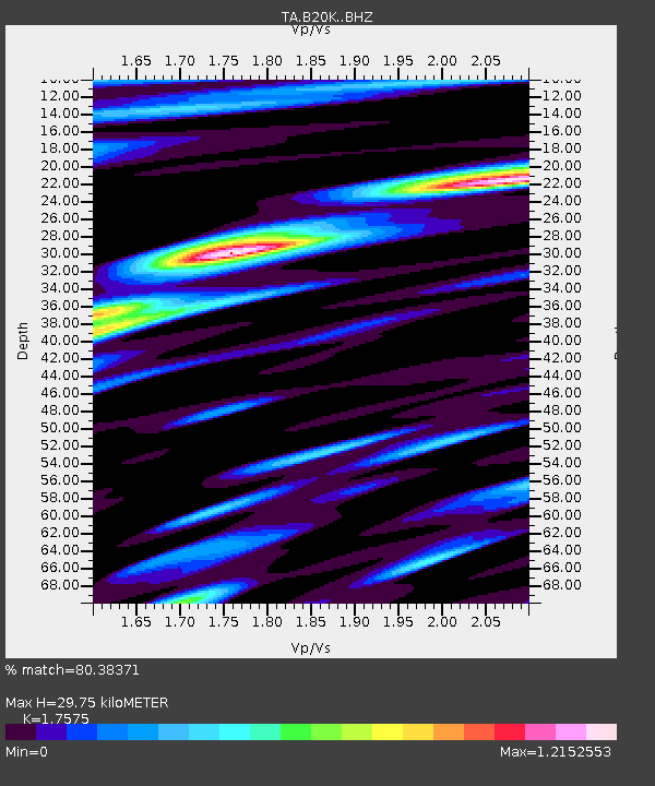
| Estimated Moho Depth: |
29.75 km |
| Estimated Crust Vp/Vs: |
1.76 |
| Assumed Crust Vp: |
6.048 km/s |
| Estimated Crust Vs: |
3.441 km/s |
| Estimated Crust Poisson's Ratio: |
0.26 |
|
| Radial Match: |
80.38371 % |
| Radial Bump: |
400 |
| Transverse Match: |
68.556946 % |
| Transverse Bump: |
400 |
| SOD ConfigId: |
21709731 |
| Insert Time: |
2020-07-07 07:54:55.042 +0000 |
| GWidth: |
2.5 |
| Max Bumps: |
400 |
| Tol: |
0.001 |
|

Signal To Noise
| Channel | StoN | STA | LTA |
| TA:B20K: :BHZ:20200623T07:55:27.449979Z | 20.13429 | 1.7832621E-6 | 8.8568406E-8 |
| TA:B20K: :BHN:20200623T07:55:27.449979Z | 1.6828488 | 1.7676527E-7 | 1.05039305E-7 |
| TA:B20K: :BHE:20200623T07:55:27.449979Z | 7.1384487 | 6.159962E-7 | 8.629272E-8 |
| Arrivals |
| Ps | 3.8 SECOND |
| PpPs | 13 SECOND |
| PsPs/PpSs | 17 SECOND |


