You are here: Home > Network List > TA - USArray Transportable Network (new EarthScope stations) Stations List
> Station H20K Anotleneega Mountain, AK, USA > Earthquake Result Viewer
H20K Anotleneega Mountain, AK, USA - Earthquake Result Viewer
| Earthquake location: |
Minahassa Peninsula, Sulawesi |
| Earthquake latitude/longitude: |
0.1/123.8 |
| Earthquake time(UTC): |
2020/06/23 (175) 07:43:28 GMT |
| Earthquake Depth: |
102 km |
| Earthquake Magnitude: |
5.9 mww |
| Earthquake Catalog/Contributor: |
NEIC PDE/us |
|
| Network: |
TA USArray Transportable Network (new EarthScope stations) |
| Station: |
H20K Anotleneega Mountain, AK, USA |
| Lat/Lon: |
65.49 N/154.88 W |
| Elevation: |
514 m |
|
| Distance: |
86.3 deg |
| Az: |
24.406 deg |
| Baz: |
262.126 deg |
| Ray Param: |
0.04390867 |
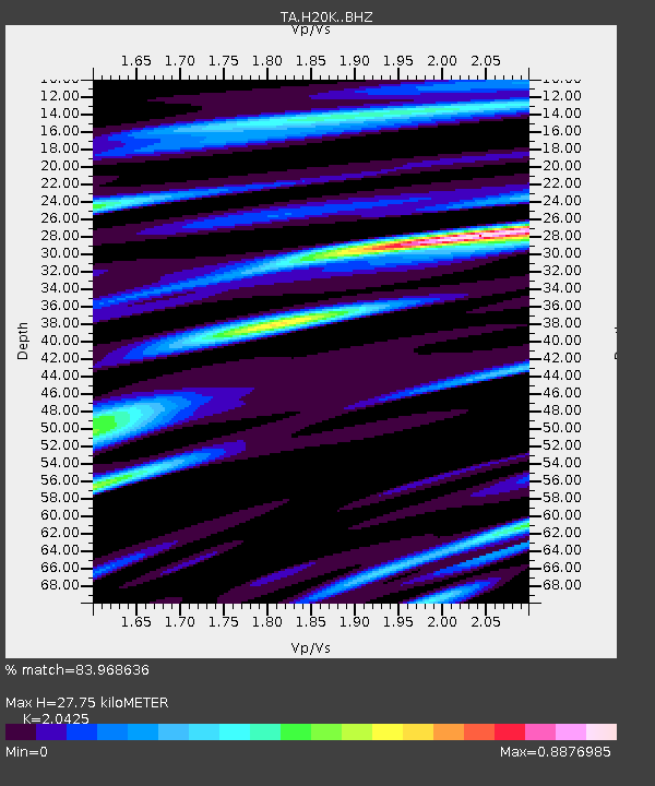
| Estimated Moho Depth: |
27.75 km |
| Estimated Crust Vp/Vs: |
2.04 |
| Assumed Crust Vp: |
6.566 km/s |
| Estimated Crust Vs: |
3.215 km/s |
| Estimated Crust Poisson's Ratio: |
0.34 |
|
| Radial Match: |
83.968636 % |
| Radial Bump: |
400 |
| Transverse Match: |
65.90129 % |
| Transverse Bump: |
400 |
| SOD ConfigId: |
21709731 |
| Insert Time: |
2020-07-07 07:56:28.064 +0000 |
| GWidth: |
2.5 |
| Max Bumps: |
400 |
| Tol: |
0.001 |
|

Signal To Noise
| Channel | StoN | STA | LTA |
| TA:H20K: :BHZ:20200623T07:55:28.149991Z | 8.168101 | 6.289539E-7 | 7.700123E-8 |
| TA:H20K: :BHN:20200623T07:55:28.149991Z | 2.0463548 | 1.4813894E-7 | 7.2391614E-8 |
| TA:H20K: :BHE:20200623T07:55:28.149991Z | 4.610448 | 2.2667179E-7 | 4.916481E-8 |
| Arrivals |
| Ps | 4.5 SECOND |
| PpPs | 13 SECOND |
| PsPs/PpSs | 17 SECOND |


