You are here: Home > Network List > 1E - GSC-BCOGC Induced Seismicity Study Stations List
> Station MONTA Z > Earthquake Result Viewer
MONTA Z - Earthquake Result Viewer
| Earthquake location: |
Near Coast Of Oaxaca, Mexico |
| Earthquake latitude/longitude: |
15.9/-95.9 |
| Earthquake time(UTC): |
2020/06/23 (175) 15:29:04 GMT |
| Earthquake Depth: |
20 km |
| Earthquake Magnitude: |
7.4 mww |
| Earthquake Catalog/Contributor: |
NEIC PDE/us |
|
| Network: |
1E GSC-BCOGC Induced Seismicity Study |
| Station: |
MONTA Z |
| Lat/Lon: |
56.10 N/121.07 W |
| Elevation: |
651 m |
|
| Distance: |
44.4 deg |
| Az: |
340.133 deg |
| Baz: |
144.298 deg |
| Ray Param: |
0.07190277 |
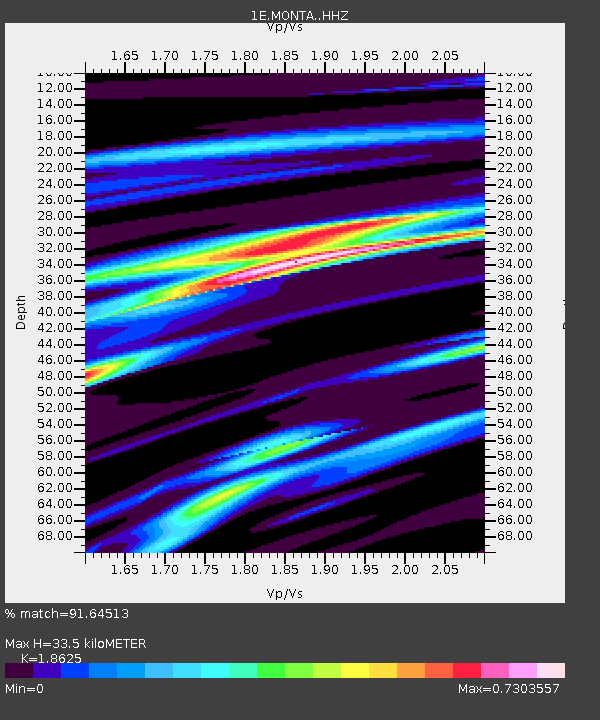
| Estimated Moho Depth: |
33.5 km |
| Estimated Crust Vp/Vs: |
1.86 |
| Assumed Crust Vp: |
6.291 km/s |
| Estimated Crust Vs: |
3.378 km/s |
| Estimated Crust Poisson's Ratio: |
0.30 |
|
| Radial Match: |
91.64513 % |
| Radial Bump: |
249 |
| Transverse Match: |
49.161007 % |
| Transverse Bump: |
400 |
| SOD ConfigId: |
21709731 |
| Insert Time: |
2020-07-07 15:29:30.782 +0000 |
| GWidth: |
2.5 |
| Max Bumps: |
400 |
| Tol: |
0.001 |
|

Signal To Noise
| Channel | StoN | STA | LTA |
| 1E:MONTA: :HHZ:20200623T15:36:43.159996Z | 11.075191 | 1.7592816E-5 | 1.5884888E-6 |
| 1E:MONTA: :HHN:20200623T15:36:43.159996Z | 3.0585887 | 1.1474965E-5 | 3.7517184E-6 |
| 1E:MONTA: :HHE:20200623T15:36:43.159996Z | 1.3030634 | 7.4202594E-6 | 5.694473E-6 |
| Arrivals |
| Ps | 4.9 SECOND |
| PpPs | 14 SECOND |
| PsPs/PpSs | 19 SECOND |


