You are here: Home > Network List > AK - Alaska Regional Network Stations List
> Station ATKA Atka Island Broadband > Earthquake Result Viewer
ATKA Atka Island Broadband - Earthquake Result Viewer
| Earthquake location: |
Near Coast Of Oaxaca, Mexico |
| Earthquake latitude/longitude: |
15.9/-95.9 |
| Earthquake time(UTC): |
2020/06/23 (175) 15:29:04 GMT |
| Earthquake Depth: |
20 km |
| Earthquake Magnitude: |
7.4 mww |
| Earthquake Catalog/Contributor: |
NEIC PDE/us |
|
| Network: |
AK Alaska Regional Network |
| Station: |
ATKA Atka Island Broadband |
| Lat/Lon: |
52.20 N/174.20 W |
| Elevation: |
55 m |
|
| Distance: |
70.4 deg |
| Az: |
320.235 deg |
| Baz: |
89.174 deg |
| Ray Param: |
0.055006135 |
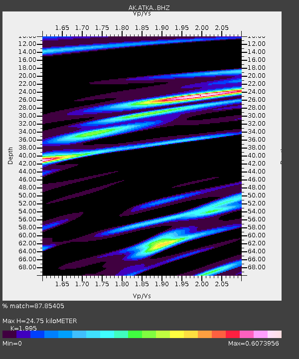
| Estimated Moho Depth: |
24.75 km |
| Estimated Crust Vp/Vs: |
2.00 |
| Assumed Crust Vp: |
5.88 km/s |
| Estimated Crust Vs: |
2.948 km/s |
| Estimated Crust Poisson's Ratio: |
0.33 |
|
| Radial Match: |
87.85405 % |
| Radial Bump: |
368 |
| Transverse Match: |
74.826744 % |
| Transverse Bump: |
400 |
| SOD ConfigId: |
21709731 |
| Insert Time: |
2020-07-07 15:29:51.477 +0000 |
| GWidth: |
2.5 |
| Max Bumps: |
400 |
| Tol: |
0.001 |
|

Signal To Noise
| Channel | StoN | STA | LTA |
| AK:ATKA: :BHZ:20200623T15:39:45.827995Z | 72.18142 | 1.36711615E-5 | 1.8940001E-7 |
| AK:ATKA: :BHN:20200623T15:39:45.827995Z | 1.9891459 | 4.887792E-7 | 2.4572316E-7 |
| AK:ATKA: :BHE:20200623T15:39:45.827995Z | 13.02482 | 6.1181718E-6 | 4.6973176E-7 |
| Arrivals |
| Ps | 4.3 SECOND |
| PpPs | 12 SECOND |
| PsPs/PpSs | 17 SECOND |


