You are here: Home > Network List > AK - Alaska Regional Network Stations List
> Station Q19K Cape Douglas, AK, USA > Earthquake Result Viewer
Q19K Cape Douglas, AK, USA - Earthquake Result Viewer
| Earthquake location: |
Near Coast Of Oaxaca, Mexico |
| Earthquake latitude/longitude: |
15.9/-95.9 |
| Earthquake time(UTC): |
2020/06/23 (175) 15:29:04 GMT |
| Earthquake Depth: |
20 km |
| Earthquake Magnitude: |
7.4 mww |
| Earthquake Catalog/Contributor: |
NEIC PDE/us |
|
| Network: |
AK Alaska Regional Network |
| Station: |
Q19K Cape Douglas, AK, USA |
| Lat/Lon: |
58.93 N/153.64 W |
| Elevation: |
631 m |
|
| Distance: |
60.0 deg |
| Az: |
329.59 deg |
| Baz: |
110.121 deg |
| Ray Param: |
0.061781522 |
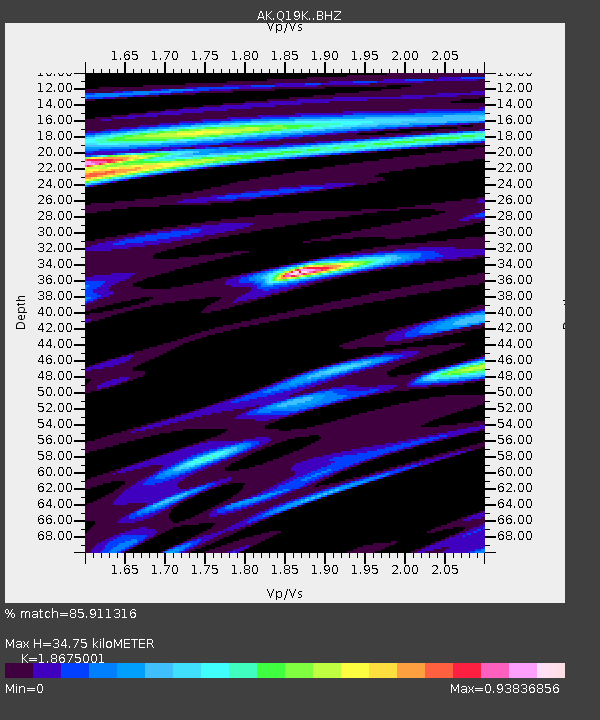
| Estimated Moho Depth: |
34.75 km |
| Estimated Crust Vp/Vs: |
1.87 |
| Assumed Crust Vp: |
5.989 km/s |
| Estimated Crust Vs: |
3.207 km/s |
| Estimated Crust Poisson's Ratio: |
0.30 |
|
| Radial Match: |
85.911316 % |
| Radial Bump: |
400 |
| Transverse Match: |
72.71933 % |
| Transverse Bump: |
400 |
| SOD ConfigId: |
21709731 |
| Insert Time: |
2020-07-07 15:31:52.293 +0000 |
| GWidth: |
2.5 |
| Max Bumps: |
400 |
| Tol: |
0.001 |
|

Signal To Noise
| Channel | StoN | STA | LTA |
| AK:Q19K: :BHZ:20200623T15:38:38.619987Z | 102.31264 | 1.2121514E-5 | 1.1847524E-7 |
| AK:Q19K: :BHN:20200623T15:38:38.619987Z | 7.336635 | 9.723278E-7 | 1.3253047E-7 |
| AK:Q19K: :BHE:20200623T15:38:38.619987Z | 26.818123 | 5.135048E-6 | 1.9147679E-7 |
| Arrivals |
| Ps | 5.2 SECOND |
| PpPs | 16 SECOND |
| PsPs/PpSs | 21 SECOND |


