You are here: Home > Network List > AV - Alaska Volcano Observatory Stations List
> Station ADAG Mount Adagdak, Regional Station, Alaska > Earthquake Result Viewer
ADAG Mount Adagdak, Regional Station, Alaska - Earthquake Result Viewer
| Earthquake location: |
Near Coast Of Oaxaca, Mexico |
| Earthquake latitude/longitude: |
15.9/-95.9 |
| Earthquake time(UTC): |
2020/06/23 (175) 15:29:04 GMT |
| Earthquake Depth: |
20 km |
| Earthquake Magnitude: |
7.4 mww |
| Earthquake Catalog/Contributor: |
NEIC PDE/us |
|
| Network: |
AV Alaska Volcano Observatory |
| Station: |
ADAG Mount Adagdak, Regional Station, Alaska |
| Lat/Lon: |
51.98 N/176.60 W |
| Elevation: |
281 m |
|
| Distance: |
71.9 deg |
| Az: |
320.05 deg |
| Baz: |
87.22 deg |
| Ray Param: |
0.0540179 |
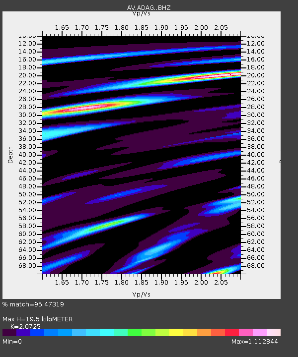
| Estimated Moho Depth: |
19.5 km |
| Estimated Crust Vp/Vs: |
2.07 |
| Assumed Crust Vp: |
5.88 km/s |
| Estimated Crust Vs: |
2.837 km/s |
| Estimated Crust Poisson's Ratio: |
0.35 |
|
| Radial Match: |
95.47319 % |
| Radial Bump: |
400 |
| Transverse Match: |
78.08116 % |
| Transverse Bump: |
400 |
| SOD ConfigId: |
21709731 |
| Insert Time: |
2020-07-07 15:33:01.670 +0000 |
| GWidth: |
2.5 |
| Max Bumps: |
400 |
| Tol: |
0.001 |
|

Signal To Noise
| Channel | StoN | STA | LTA |
| AV:ADAG: :BHZ:20200623T15:39:54.819023Z | 56.248234 | 8.320645E-6 | 1.4792721E-7 |
| AV:ADAG: :BHN:20200623T15:39:54.819023Z | 3.4320743 | 9.0147694E-7 | 2.626624E-7 |
| AV:ADAG: :BHE:20200623T15:39:54.819023Z | 14.900585 | 3.9233723E-6 | 2.6330324E-7 |
| Arrivals |
| Ps | 3.6 SECOND |
| PpPs | 9.9 SECOND |
| PsPs/PpSs | 14 SECOND |


