You are here: Home > Network List > AV - Alaska Volcano Observatory Stations List
> Station GAKI Kavalga Island, Gareloi Volcano, Alaska > Earthquake Result Viewer
GAKI Kavalga Island, Gareloi Volcano, Alaska - Earthquake Result Viewer
| Earthquake location: |
Near Coast Of Oaxaca, Mexico |
| Earthquake latitude/longitude: |
15.9/-95.9 |
| Earthquake time(UTC): |
2020/06/23 (175) 15:29:04 GMT |
| Earthquake Depth: |
20 km |
| Earthquake Magnitude: |
7.4 mww |
| Earthquake Catalog/Contributor: |
NEIC PDE/us |
|
| Network: |
AV Alaska Volcano Observatory |
| Station: |
GAKI Kavalga Island, Gareloi Volcano, Alaska |
| Lat/Lon: |
51.55 N/178.81 W |
| Elevation: |
99 m |
|
| Distance: |
73.3 deg |
| Az: |
319.695 deg |
| Baz: |
85.381 deg |
| Ray Param: |
0.05308459 |
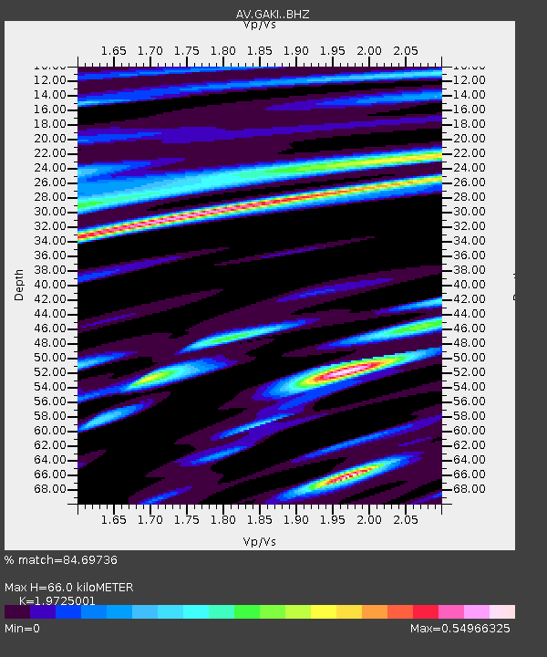
| Estimated Moho Depth: |
66.0 km |
| Estimated Crust Vp/Vs: |
1.97 |
| Assumed Crust Vp: |
6.048 km/s |
| Estimated Crust Vs: |
3.066 km/s |
| Estimated Crust Poisson's Ratio: |
0.33 |
|
| Radial Match: |
84.69736 % |
| Radial Bump: |
400 |
| Transverse Match: |
51.187717 % |
| Transverse Bump: |
400 |
| SOD ConfigId: |
21709731 |
| Insert Time: |
2020-07-07 15:33:38.414 +0000 |
| GWidth: |
2.5 |
| Max Bumps: |
400 |
| Tol: |
0.001 |
|

Signal To Noise
| Channel | StoN | STA | LTA |
| AV:GAKI: :BHZ:20200623T15:40:03.140007Z | 52.96916 | 8.398892E-6 | 1.5856193E-7 |
| AV:GAKI: :BHN:20200623T15:40:03.140007Z | 6.0306506 | 1.5850715E-6 | 2.628359E-7 |
| AV:GAKI: :BHE:20200623T15:40:03.140007Z | 8.185378 | 2.7684118E-6 | 3.3821428E-7 |
| Arrivals |
| Ps | 11 SECOND |
| PpPs | 32 SECOND |
| PsPs/PpSs | 42 SECOND |


