You are here: Home > Network List > AV - Alaska Volcano Observatory Stations List
> Station GASW Southwest, Gareloi Volcano, Alaska > Earthquake Result Viewer
GASW Southwest, Gareloi Volcano, Alaska - Earthquake Result Viewer
| Earthquake location: |
Near Coast Of Oaxaca, Mexico |
| Earthquake latitude/longitude: |
15.9/-95.9 |
| Earthquake time(UTC): |
2020/06/23 (175) 15:29:04 GMT |
| Earthquake Depth: |
20 km |
| Earthquake Magnitude: |
7.4 mww |
| Earthquake Catalog/Contributor: |
NEIC PDE/us |
|
| Network: |
AV Alaska Volcano Observatory |
| Station: |
GASW Southwest, Gareloi Volcano, Alaska |
| Lat/Lon: |
51.78 N/178.86 W |
| Elevation: |
248 m |
|
| Distance: |
73.3 deg |
| Az: |
319.932 deg |
| Baz: |
85.415 deg |
| Ray Param: |
0.053079918 |
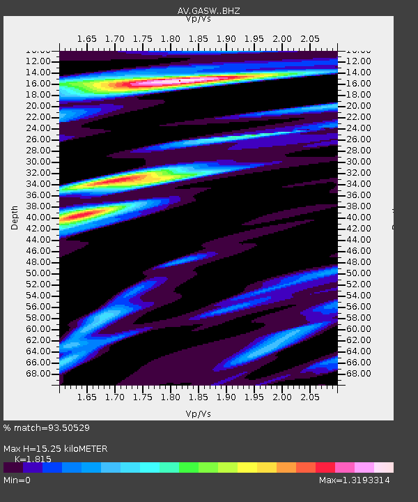
| Estimated Moho Depth: |
15.25 km |
| Estimated Crust Vp/Vs: |
1.82 |
| Assumed Crust Vp: |
6.048 km/s |
| Estimated Crust Vs: |
3.332 km/s |
| Estimated Crust Poisson's Ratio: |
0.28 |
|
| Radial Match: |
93.50529 % |
| Radial Bump: |
400 |
| Transverse Match: |
75.59548 % |
| Transverse Bump: |
400 |
| SOD ConfigId: |
21709731 |
| Insert Time: |
2020-07-07 15:33:44.096 +0000 |
| GWidth: |
2.5 |
| Max Bumps: |
400 |
| Tol: |
0.001 |
|

Signal To Noise
| Channel | StoN | STA | LTA |
| AV:GASW: :BHZ:20200623T15:40:03.179008Z | 39.15086 | 8.445904E-6 | 2.1572716E-7 |
| AV:GASW: :BHN:20200623T15:40:03.179008Z | 2.94166 | 1.1800678E-6 | 4.0115708E-7 |
| AV:GASW: :BHE:20200623T15:40:03.179008Z | 10.055645 | 3.4760612E-6 | 3.456826E-7 |
| Arrivals |
| Ps | 2.1 SECOND |
| PpPs | 6.9 SECOND |
| PsPs/PpSs | 9.0 SECOND |


