You are here: Home > Network List > AV - Alaska Volcano Observatory Stations List
> Station GSIG Igitkin Island, Great Sitkin Volcano, Alaska > Earthquake Result Viewer
GSIG Igitkin Island, Great Sitkin Volcano, Alaska - Earthquake Result Viewer
| Earthquake location: |
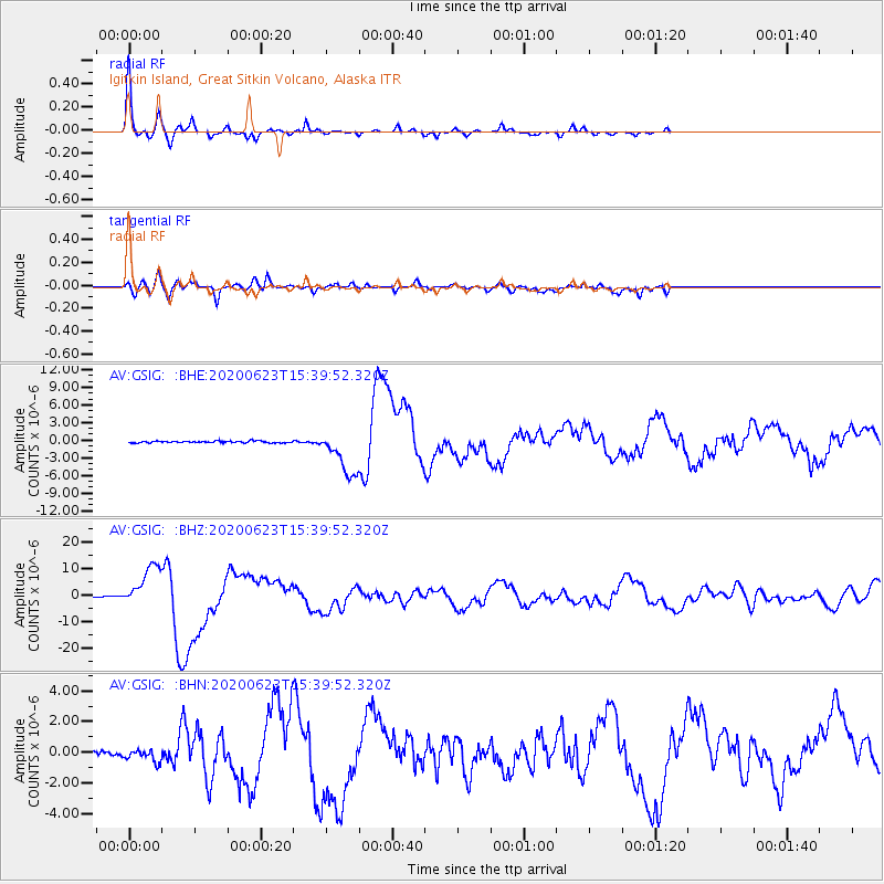
Near Coast Of Oaxaca, Mexico |
| Earthquake latitude/longitude: |
15.9/-95.9 |
| Earthquake time(UTC): |
2020/06/23 (175) 15:29:04 GMT |
| Earthquake Depth: |
20 km |
| Earthquake Magnitude: |
7.4 mww |
| Earthquake Catalog/Contributor: |
NEIC PDE/us |
|
| Network: |
AV Alaska Volcano Observatory |
| Station: |
GSIG Igitkin Island, Great Sitkin Volcano, Alaska |
| Lat/Lon: |
51.99 N/175.93 W |
| Elevation: |
407 m |
|
| Distance: |
71.5 deg |
| Az: |
320.036 deg |
| Baz: |
87.746 deg |
| Ray Param: |
0.054296017 |
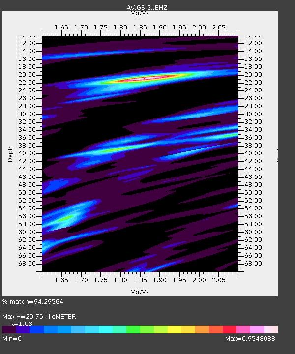
| Estimated Moho Depth: |
20.75 km |
| Estimated Crust Vp/Vs: |
1.86 |
| Assumed Crust Vp: |
3.943 km/s |
| Estimated Crust Vs: |
2.12 km/s |
| Estimated Crust Poisson's Ratio: |
0.30 |
|
| Radial Match: |
94.29564 % |
| Radial Bump: |
248 |
| Transverse Match: |
78.599915 % |
| Transverse Bump: |
400 |
| SOD ConfigId: |
21709731 |
| Insert Time: |
2020-07-07 15:33:46.537 +0000 |
| GWidth: |
2.5 |
| Max Bumps: |
400 |
| Tol: |
0.001 |
|
Signal To Noise
| Channel | StoN | STA | LTA |
| AV:GSIG: :BHZ:20200623T15:39:52.320Z | 62.709995 | 7.819269E-6 | 1.2468935E-7 |
| AV:GSIG: :BHN:20200623T15:39:52.320Z | 3.2448921 | 4.3283356E-7 | 1.333892E-7 |
| AV:GSIG: :BHE:20200623T15:39:52.320Z | 25.760038 | 3.7997636E-6 | 1.4750613E-7 |
| Arrivals |
| Ps | 4.6 SECOND |
| PpPs | 15 SECOND |
| PsPs/PpSs | 19 SECOND |


