You are here: Home > Network List > AV - Alaska Volcano Observatory Stations List
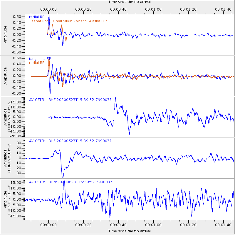
> Station GSTR Teapot Rock, Great Sitkin Volcano, Alaska > Earthquake Result Viewer
GSTR Teapot Rock, Great Sitkin Volcano, Alaska - Earthquake Result Viewer
| Earthquake location: |
Near Coast Of Oaxaca, Mexico |
| Earthquake latitude/longitude: |
15.9/-95.9 |
| Earthquake time(UTC): |
2020/06/23 (175) 15:29:04 GMT |
| Earthquake Depth: |
20 km |
| Earthquake Magnitude: |
7.4 mww |
| Earthquake Catalog/Contributor: |
NEIC PDE/us |
|
| Network: |
AV Alaska Volcano Observatory |
| Station: |
GSTR Teapot Rock, Great Sitkin Volcano, Alaska |
| Lat/Lon: |
52.09 N/176.06 W |
| Elevation: |
536 m |
|
| Distance: |
71.5 deg |
| Az: |
320.153 deg |
| Baz: |
87.678 deg |
| Ray Param: |
0.05424468 |
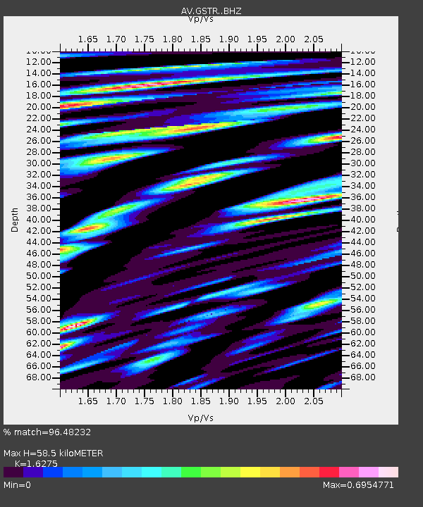
| Estimated Moho Depth: |
58.5 km |
| Estimated Crust Vp/Vs: |
1.63 |
| Assumed Crust Vp: |
3.912 km/s |
| Estimated Crust Vs: |
2.403 km/s |
| Estimated Crust Poisson's Ratio: |
0.20 |
|
| Radial Match: |
96.48232 % |
| Radial Bump: |
400 |
| Transverse Match: |
87.75854 % |
| Transverse Bump: |
400 |
| SOD ConfigId: |
21709731 |
| Insert Time: |
2020-07-07 15:33:52.180 +0000 |
| GWidth: |
2.5 |
| Max Bumps: |
400 |
| Tol: |
0.001 |
|
Signal To Noise
| Channel | StoN | STA | LTA |
| AV:GSTR: :BHZ:20200623T15:39:52.799003Z | 43.800716 | 8.613394E-6 | 1.9664962E-7 |
| AV:GSTR: :BHN:20200623T15:39:52.799003Z | 2.6971884 | 1.7398238E-6 | 6.450509E-7 |
| AV:GSTR: :BHE:20200623T15:39:52.799003Z | 8.801221 | 3.876883E-6 | 4.4049375E-7 |
| Arrivals |
| Ps | 9.5 SECOND |
| PpPs | 39 SECOND |
| PsPs/PpSs | 48 SECOND |


