You are here: Home > Network List > AV - Alaska Volcano Observatory Stations List
> Station PLK2 Mt. Peulik Volcano 2, Alaska > Earthquake Result Viewer
PLK2 Mt. Peulik Volcano 2, Alaska - Earthquake Result Viewer

| Earthquake location: |
Near Coast Of Oaxaca, Mexico |
| Earthquake latitude/longitude: |
15.9/-95.9 |
| Earthquake time(UTC): |
2020/06/23 (175) 15:29:04 GMT |
| Earthquake Depth: |
20 km |
| Earthquake Magnitude: |
7.4 mww |
| Earthquake Catalog/Contributor: |
NEIC PDE/us |
|
| Network: |
AV Alaska Volcano Observatory |
| Station: |
PLK2 Mt. Peulik Volcano 2, Alaska |
| Lat/Lon: |
57.76 N/156.33 W |
| Elevation: |
401 m |
|
| Distance: |
61.0 deg |
| Az: |
327.8 deg |
| Baz: |
106.961 deg |
| Ray Param: |
0.061159708 |
| Estimated Moho Depth: |
26.5 km |
| Estimated Crust Vp/Vs: |
1.60 |
| Assumed Crust Vp: |
6.1 km/s |
| Estimated Crust Vs: |
3.807 km/s |
| Estimated Crust Poisson's Ratio: |
0.18 |
|
| Radial Match: |
96.927345 % |
| Radial Bump: |
261 |
| Transverse Match: |
62.389214 % |
| Transverse Bump: |
400 |
| SOD ConfigId: |
21709731 |
| Insert Time: |
2020-07-07 15:34:33.811 +0000 |
| GWidth: |
2.5 |
| Max Bumps: |
400 |
| Tol: |
0.001 |
|
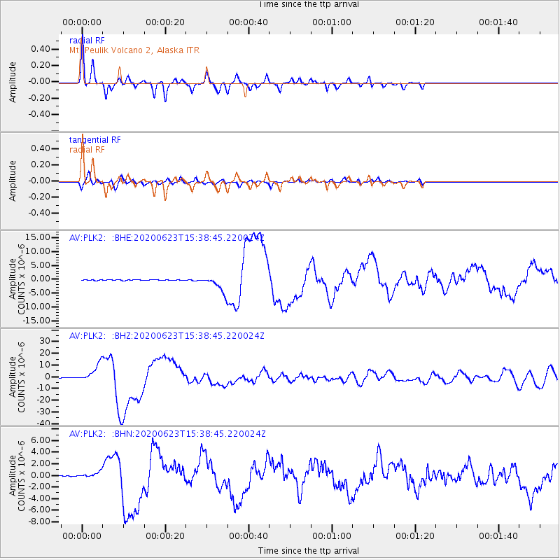
Signal To Noise
| Channel | StoN | STA | LTA |
| AV:PLK2: :BHZ:20200623T15:38:45.220024Z | 71.799706 | 7.618568E-6 | 1.0610862E-7 |
| AV:PLK2: :BHN:20200623T15:38:45.220024Z | 4.7195787 | 4.9508543E-7 | 1.04900344E-7 |
| AV:PLK2: :BHE:20200623T15:38:45.220024Z | 27.211014 | 3.013838E-6 | 1.1075802E-7 |
| Arrivals |
| Ps | 2.7 SECOND |
| PpPs | 11 SECOND |
| PsPs/PpSs | 14 SECOND |


