You are here: Home > Network List > KN - Kyrgyz Seismic Telemetry Network Stations List
> Station ULHL KN.ULHL > Earthquake Result Viewer
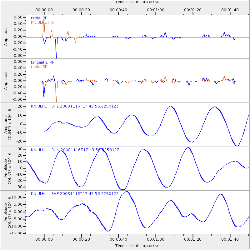
ULHL KN.ULHL - Earthquake Result Viewer
*The percent match for this event was below the threshold and hence no stack was calculated.
| Earthquake location: |
Minahassa Peninsula, Sulawesi |
| Earthquake latitude/longitude: |
1.3/122.1 |
| Earthquake time(UTC): |
2008/11/16 (321) 17:34:38 GMT |
| Earthquake Depth: |
35 km |
| Earthquake Magnitude: |
5.6 MB |
| Earthquake Catalog/Contributor: |
WHDF/NEIC |
|
| Network: |
KN Kyrgyz Seismic Telemetry Network |
| Station: |
ULHL KN.ULHL |
| Lat/Lon: |
42.25 N/76.24 E |
| Elevation: |
2040 m |
|
| Distance: |
57.9 deg |
| Az: |
321.001 deg |
| Baz: |
122.078 deg |
| Ray Param: |
$rayparam |
*The percent match for this event was below the threshold and hence was not used in the summary stack. |
|
| Radial Match: |
90.489655 % |
| Radial Bump: |
336 |
| Transverse Match: |
88.717995 % |
| Transverse Bump: |
281 |
| SOD ConfigId: |
2658 |
| Insert Time: |
2010-03-08 22:02:43.193 +0000 |
| GWidth: |
2.5 |
| Max Bumps: |
400 |
| Tol: |
0.001 |
|
Signal To Noise
| Channel | StoN | STA | LTA |
| KN:ULHL: :BHN:20081116T17:43:56.225012Z | 2.6464002 | 1.9331466E-5 | 7.304816E-6 |
| KN:ULHL: :BHE:20081116T17:43:56.225012Z | 0.59694767 | 1.9414335E-6 | 3.2522673E-6 |
| KN:ULHL: :BHZ:20081116T17:43:56.225012Z | 1.9196681 | 5.742779E-6 | 2.991548E-6 |
| Arrivals |
| Ps | |
| PpPs | |
| PsPs/PpSs | |


