You are here: Home > Network List > AV - Alaska Volcano Observatory Stations List
> Station TAFL Flats, Tanaga Volcano, Alaska > Earthquake Result Viewer
TAFL Flats, Tanaga Volcano, Alaska - Earthquake Result Viewer
| Earthquake location: |
Near Coast Of Oaxaca, Mexico |
| Earthquake latitude/longitude: |
15.9/-95.9 |
| Earthquake time(UTC): |
2020/06/23 (175) 15:29:04 GMT |
| Earthquake Depth: |
20 km |
| Earthquake Magnitude: |
7.4 mww |
| Earthquake Catalog/Contributor: |
NEIC PDE/us |
|
| Network: |
AV Alaska Volcano Observatory |
| Station: |
TAFL Flats, Tanaga Volcano, Alaska |
| Lat/Lon: |
51.76 N/177.90 W |
| Elevation: |
186 m |
|
| Distance: |
72.7 deg |
| Az: |
319.863 deg |
| Baz: |
86.145 deg |
| Ray Param: |
0.0534783 |
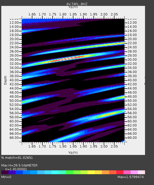
| Estimated Moho Depth: |
29.5 km |
| Estimated Crust Vp/Vs: |
1.81 |
| Assumed Crust Vp: |
5.88 km/s |
| Estimated Crust Vs: |
3.249 km/s |
| Estimated Crust Poisson's Ratio: |
0.28 |
|
| Radial Match: |
81.82651 % |
| Radial Bump: |
400 |
| Transverse Match: |
66.31532 % |
| Transverse Bump: |
400 |
| SOD ConfigId: |
21709731 |
| Insert Time: |
2020-07-07 15:34:59.706 +0000 |
| GWidth: |
2.5 |
| Max Bumps: |
400 |
| Tol: |
0.001 |
|

Signal To Noise
| Channel | StoN | STA | LTA |
| AV:TAFL: :BHZ:20200623T15:39:59.700004Z | 32.152744 | 8.22431E-6 | 2.5578873E-7 |
| AV:TAFL: :BHN:20200623T15:39:59.700004Z | 0.9195014 | 5.453745E-7 | 5.9311975E-7 |
| AV:TAFL: :BHE:20200623T15:39:59.700004Z | 7.286121 | 3.7694008E-6 | 5.1733986E-7 |
| Arrivals |
| Ps | 4.2 SECOND |
| PpPs | 14 SECOND |
| PsPs/PpSs | 18 SECOND |


