You are here: Home > Network List > AV - Alaska Volcano Observatory Stations List
> Station TAFP Falls Point, Tanaga Volcano, Alaska > Earthquake Result Viewer
TAFP Falls Point, Tanaga Volcano, Alaska - Earthquake Result Viewer
| Earthquake location: |
Near Coast Of Oaxaca, Mexico |
| Earthquake latitude/longitude: |
15.9/-95.9 |
| Earthquake time(UTC): |
2020/06/23 (175) 15:29:04 GMT |
| Earthquake Depth: |
20 km |
| Earthquake Magnitude: |
7.4 mww |
| Earthquake Catalog/Contributor: |
NEIC PDE/us |
|
| Network: |
AV Alaska Volcano Observatory |
| Station: |
TAFP Falls Point, Tanaga Volcano, Alaska |
| Lat/Lon: |
51.90 N/177.99 W |
| Elevation: |
440 m |
|
| Distance: |
72.7 deg |
| Az: |
320.016 deg |
| Baz: |
86.124 deg |
| Ray Param: |
0.053449754 |
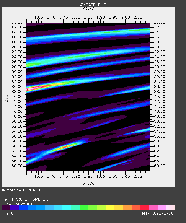
| Estimated Moho Depth: |
36.75 km |
| Estimated Crust Vp/Vs: |
1.60 |
| Assumed Crust Vp: |
5.88 km/s |
| Estimated Crust Vs: |
3.67 km/s |
| Estimated Crust Poisson's Ratio: |
0.18 |
|
| Radial Match: |
95.20423 % |
| Radial Bump: |
400 |
| Transverse Match: |
80.30696 % |
| Transverse Bump: |
399 |
| SOD ConfigId: |
21709731 |
| Insert Time: |
2020-07-07 15:35:01.373 +0000 |
| GWidth: |
2.5 |
| Max Bumps: |
400 |
| Tol: |
0.001 |
|

Signal To Noise
| Channel | StoN | STA | LTA |
| AV:TAFP: :BHZ:20200623T15:39:59.958977Z | 52.923088 | 8.047971E-6 | 1.5206919E-7 |
| AV:TAFP: :BHN:20200623T15:39:59.958977Z | 2.2551844 | 4.3154148E-7 | 1.9135531E-7 |
| AV:TAFP: :BHE:20200623T15:39:59.958977Z | 18.831919 | 3.4148734E-6 | 1.8133433E-7 |
| Arrivals |
| Ps | 3.9 SECOND |
| PpPs | 16 SECOND |
| PsPs/PpSs | 20 SECOND |


