You are here: Home > Network List > AV - Alaska Volcano Observatory Stations List
> Station TANO North, Tanaga Volcano, Alaska > Earthquake Result Viewer
TANO North, Tanaga Volcano, Alaska - Earthquake Result Viewer
| Earthquake location: |
Near Coast Of Oaxaca, Mexico |
| Earthquake latitude/longitude: |
15.9/-95.9 |
| Earthquake time(UTC): |
2020/06/23 (175) 15:29:04 GMT |
| Earthquake Depth: |
20 km |
| Earthquake Magnitude: |
7.4 mww |
| Earthquake Catalog/Contributor: |
NEIC PDE/us |
|
| Network: |
AV Alaska Volcano Observatory |
| Station: |
TANO North, Tanaga Volcano, Alaska |
| Lat/Lon: |
51.91 N/178.12 W |
| Elevation: |
269 m |
|
| Distance: |
72.8 deg |
| Az: |
320.039 deg |
| Baz: |
86.022 deg |
| Ray Param: |
0.053393938 |
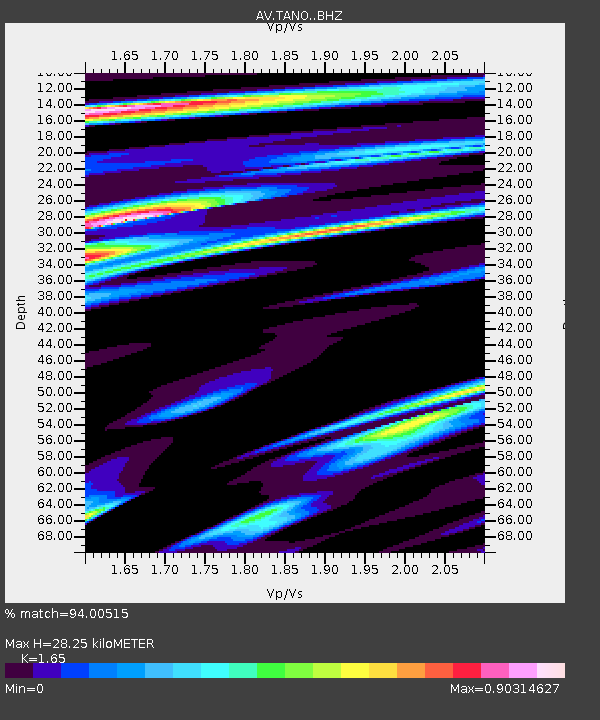
| Estimated Moho Depth: |
28.25 km |
| Estimated Crust Vp/Vs: |
1.65 |
| Assumed Crust Vp: |
6.048 km/s |
| Estimated Crust Vs: |
3.665 km/s |
| Estimated Crust Poisson's Ratio: |
0.21 |
|
| Radial Match: |
94.00515 % |
| Radial Bump: |
400 |
| Transverse Match: |
83.330795 % |
| Transverse Bump: |
400 |
| SOD ConfigId: |
21709731 |
| Insert Time: |
2020-07-07 15:35:02.560 +0000 |
| GWidth: |
2.5 |
| Max Bumps: |
400 |
| Tol: |
0.001 |
|
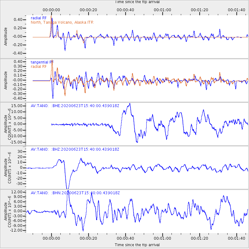
Signal To Noise
| Channel | StoN | STA | LTA |
| AV:TANO: :BHZ:20200623T15:40:00.439018Z | 29.306526 | 8.695436E-6 | 2.967065E-7 |
| AV:TANO: :BHN:20200623T15:40:00.439018Z | 2.6768618 | 1.3768632E-6 | 5.143572E-7 |
| AV:TANO: :BHE:20200623T15:40:00.439018Z | 8.677686 | 3.2803794E-6 | 3.7802465E-7 |
| Arrivals |
| Ps | 3.1 SECOND |
| PpPs | 12 SECOND |
| PsPs/PpSs | 15 SECOND |


