You are here: Home > Network List > C1 - Red Sismologica Nacional Stations List
> Station MG03 ISLA DAWSON > Earthquake Result Viewer
MG03 ISLA DAWSON - Earthquake Result Viewer
| Earthquake location: |
Near Coast Of Oaxaca, Mexico |
| Earthquake latitude/longitude: |
15.9/-95.9 |
| Earthquake time(UTC): |
2020/06/23 (175) 15:29:04 GMT |
| Earthquake Depth: |
20 km |
| Earthquake Magnitude: |
7.4 mww |
| Earthquake Catalog/Contributor: |
NEIC PDE/us |
|
| Network: |
C1 Red Sismologica Nacional |
| Station: |
MG03 ISLA DAWSON |
| Lat/Lon: |
53.85 S/70.46 W |
| Elevation: |
83 m |
|
| Distance: |
72.8 deg |
| Az: |
164.532 deg |
| Baz: |
334.339 deg |
| Ray Param: |
0.05338188 |
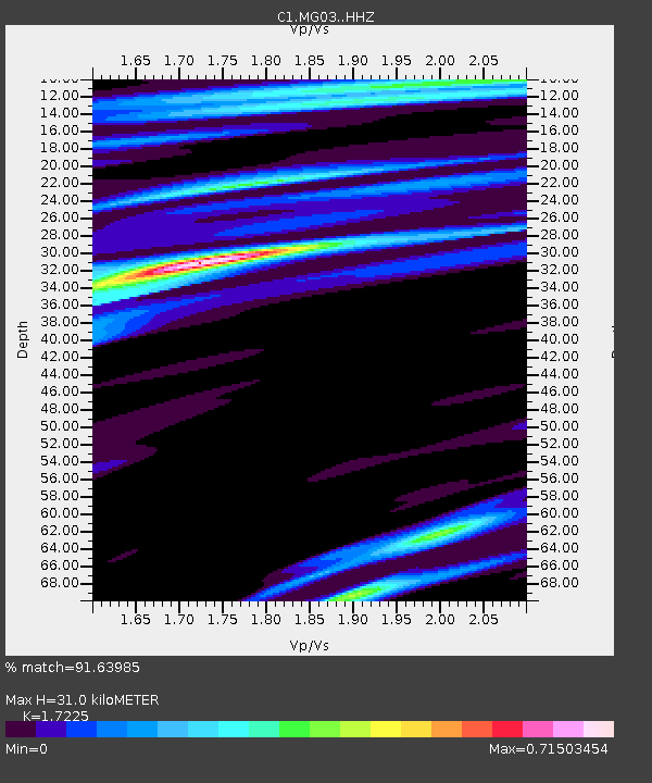
| Estimated Moho Depth: |
31.0 km |
| Estimated Crust Vp/Vs: |
1.72 |
| Assumed Crust Vp: |
6.079 km/s |
| Estimated Crust Vs: |
3.529 km/s |
| Estimated Crust Poisson's Ratio: |
0.25 |
|
| Radial Match: |
91.63985 % |
| Radial Bump: |
297 |
| Transverse Match: |
74.15714 % |
| Transverse Bump: |
400 |
| SOD ConfigId: |
21709731 |
| Insert Time: |
2020-07-07 15:36:08.011 +0000 |
| GWidth: |
2.5 |
| Max Bumps: |
400 |
| Tol: |
0.001 |
|

Signal To Noise
| Channel | StoN | STA | LTA |
| C1:MG03: :HHZ:20200623T15:40:00.54998Z | 2.5918903 | 1.8905776E-6 | 7.294204E-7 |
| C1:MG03: :HHN:20200623T15:40:00.54998Z | 0.81363434 | 6.0871434E-7 | 7.4814244E-7 |
| C1:MG03: :HHE:20200623T15:40:00.54998Z | 0.36796632 | 2.6181135E-7 | 7.11509E-7 |
| Arrivals |
| Ps | 3.8 SECOND |
| PpPs | 13 SECOND |
| PsPs/PpSs | 17 SECOND |


