You are here: Home > Network List > CC - Cascade Chain Volcano Monitoring Stations List
> Station REM Rembrant, Mount St. Helens > Earthquake Result Viewer
REM Rembrant, Mount St. Helens - Earthquake Result Viewer
| Earthquake location: |
Near Coast Of Oaxaca, Mexico |
| Earthquake latitude/longitude: |
15.9/-95.9 |
| Earthquake time(UTC): |
2020/06/23 (175) 15:29:04 GMT |
| Earthquake Depth: |
20 km |
| Earthquake Magnitude: |
7.4 mww |
| Earthquake Catalog/Contributor: |
NEIC PDE/us |
|
| Network: |
CC Cascade Chain Volcano Monitoring |
| Station: |
REM Rembrant, Mount St. Helens |
| Lat/Lon: |
46.20 N/122.19 W |
| Elevation: |
1905 m |
|
| Distance: |
37.3 deg |
| Az: |
329.535 deg |
| Baz: |
135.389 deg |
| Ray Param: |
0.076203965 |
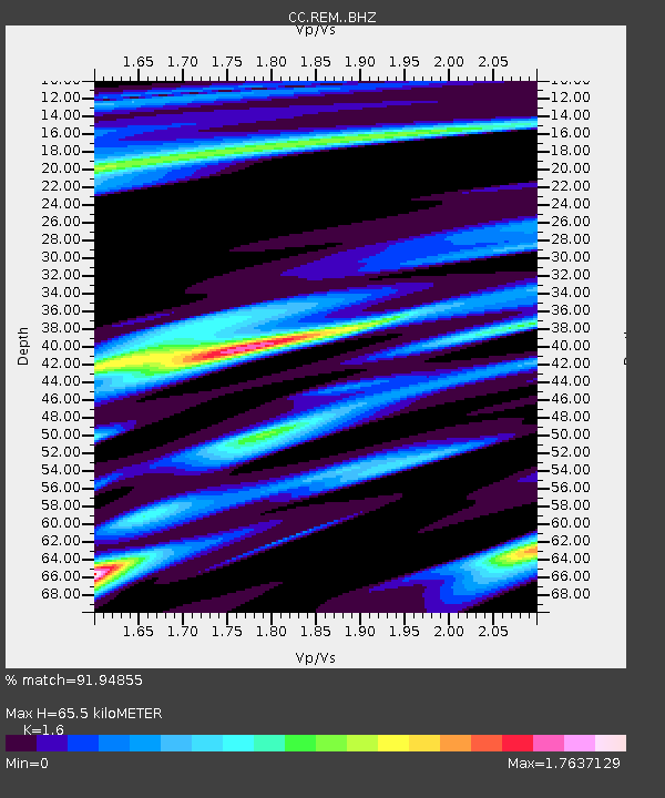
| Estimated Moho Depth: |
65.5 km |
| Estimated Crust Vp/Vs: |
1.60 |
| Assumed Crust Vp: |
6.566 km/s |
| Estimated Crust Vs: |
4.104 km/s |
| Estimated Crust Poisson's Ratio: |
0.18 |
|
| Radial Match: |
91.94855 % |
| Radial Bump: |
325 |
| Transverse Match: |
59.62757 % |
| Transverse Bump: |
400 |
| SOD ConfigId: |
21709731 |
| Insert Time: |
2020-07-07 15:37:19.546 +0000 |
| GWidth: |
2.5 |
| Max Bumps: |
400 |
| Tol: |
0.001 |
|

Signal To Noise
| Channel | StoN | STA | LTA |
| CC:REM: :BHZ:20200623T15:35:44.314995Z | 53.12698 | 9.561402E-6 | 1.7997263E-7 |
| CC:REM: :BHN:20200623T15:35:44.314995Z | 15.669912 | 4.155847E-6 | 2.6521187E-7 |
| CC:REM: :BHE:20200623T15:35:44.314995Z | 12.659099 | 4.3920813E-6 | 3.4695057E-7 |
| Arrivals |
| Ps | 6.5 SECOND |
| PpPs | 24 SECOND |
| PsPs/PpSs | 30 SECOND |


