You are here: Home > Network List > CN - Canadian National Seismograph Network Stations List
> Station TRQ Mont-Tremblant, QC, CA > Earthquake Result Viewer
TRQ Mont-Tremblant, QC, CA - Earthquake Result Viewer
| Earthquake location: |
Near Coast Of Oaxaca, Mexico |
| Earthquake latitude/longitude: |
15.9/-95.9 |
| Earthquake time(UTC): |
2020/06/23 (175) 15:29:04 GMT |
| Earthquake Depth: |
20 km |
| Earthquake Magnitude: |
7.4 mww |
| Earthquake Catalog/Contributor: |
NEIC PDE/us |
|
| Network: |
CN Canadian National Seismograph Network |
| Station: |
TRQ Mont-Tremblant, QC, CA |
| Lat/Lon: |
46.22 N/74.55 W |
| Elevation: |
860 m |
|
| Distance: |
35.1 deg |
| Az: |
26.136 deg |
| Baz: |
217.616 deg |
| Ray Param: |
0.07739081 |
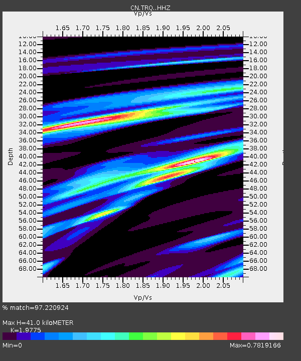
| Estimated Moho Depth: |
41.0 km |
| Estimated Crust Vp/Vs: |
1.98 |
| Assumed Crust Vp: |
6.61 km/s |
| Estimated Crust Vs: |
3.343 km/s |
| Estimated Crust Poisson's Ratio: |
0.33 |
|
| Radial Match: |
97.220924 % |
| Radial Bump: |
229 |
| Transverse Match: |
81.44448 % |
| Transverse Bump: |
400 |
| SOD ConfigId: |
21709731 |
| Insert Time: |
2020-07-07 15:40:02.782 +0000 |
| GWidth: |
2.5 |
| Max Bumps: |
400 |
| Tol: |
0.001 |
|

Signal To Noise
| Channel | StoN | STA | LTA |
| CN:TRQ: :HHZ:20200623T15:35:25.469993Z | 149.55008 | 3.3637214E-5 | 2.2492274E-7 |
| CN:TRQ: :HHN:20200623T15:35:25.469993Z | 66.42659 | 1.8850204E-5 | 2.8377497E-7 |
| CN:TRQ: :HHE:20200623T15:35:25.469993Z | 52.40908 | 1.1339516E-5 | 2.1636549E-7 |
| Arrivals |
| Ps | 6.5 SECOND |
| PpPs | 17 SECOND |
| PsPs/PpSs | 24 SECOND |


