You are here: Home > Network List > G - GEOSCOPE Stations List
> Station KIP Kipapa, Hawai, U.S.A. (Pacific Ocean) > Earthquake Result Viewer
KIP Kipapa, Hawai, U.S.A. (Pacific Ocean) - Earthquake Result Viewer
| Earthquake location: |
Near Coast Of Oaxaca, Mexico |
| Earthquake latitude/longitude: |
15.9/-95.9 |
| Earthquake time(UTC): |
2020/06/23 (175) 15:29:04 GMT |
| Earthquake Depth: |
20 km |
| Earthquake Magnitude: |
7.4 mww |
| Earthquake Catalog/Contributor: |
NEIC PDE/us |
|
| Network: |
G GEOSCOPE |
| Station: |
KIP Kipapa, Hawai, U.S.A. (Pacific Ocean) |
| Lat/Lon: |
21.42 N/158.01 W |
| Elevation: |
70 m |
|
| Distance: |
58.7 deg |
| Az: |
285.631 deg |
| Baz: |
83.918 deg |
| Ray Param: |
0.06261791 |
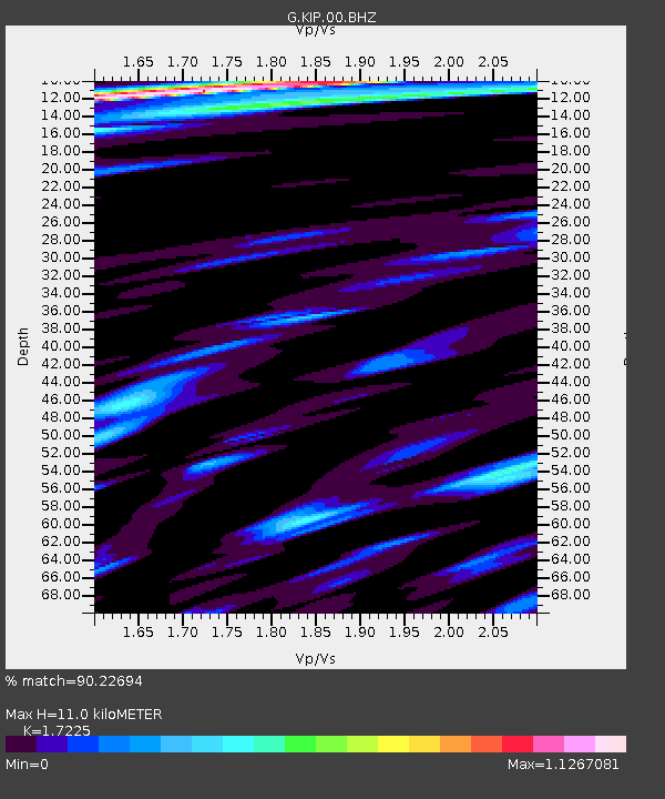
| Estimated Moho Depth: |
11.0 km |
| Estimated Crust Vp/Vs: |
1.72 |
| Assumed Crust Vp: |
4.24 km/s |
| Estimated Crust Vs: |
2.461 km/s |
| Estimated Crust Poisson's Ratio: |
0.25 |
|
| Radial Match: |
90.22694 % |
| Radial Bump: |
400 |
| Transverse Match: |
86.41468 % |
| Transverse Bump: |
389 |
| SOD ConfigId: |
21709731 |
| Insert Time: |
2020-07-07 15:41:01.512 +0000 |
| GWidth: |
2.5 |
| Max Bumps: |
400 |
| Tol: |
0.001 |
|
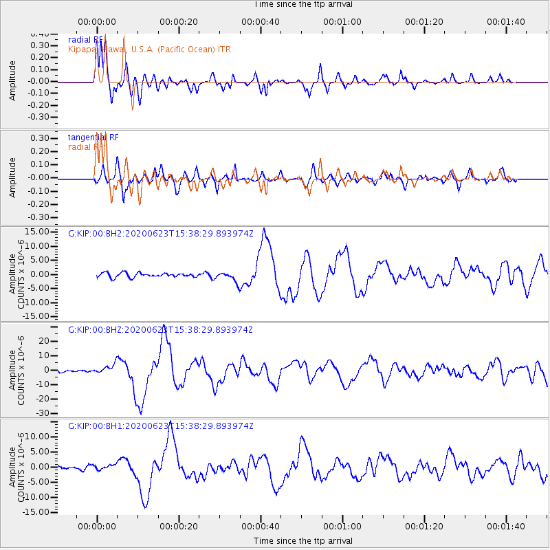
Signal To Noise
| Channel | StoN | STA | LTA |
| G:KIP:00:BHZ:20200623T15:38:29.893974Z | 4.4419827 | 3.4011864E-6 | 7.65691E-7 |
| G:KIP:00:BH1:20200623T15:38:29.893974Z | 0.80667055 | 8.1788744E-7 | 1.0139051E-6 |
| G:KIP:00:BH2:20200623T15:38:29.893974Z | 2.4309149 | 1.8428367E-6 | 7.5808356E-7 |
| Arrivals |
| Ps | 1.9 SECOND |
| PpPs | 6.9 SECOND |
| PsPs/PpSs | 8.8 SECOND |


