You are here: Home > Network List > G - GEOSCOPE Stations List
> Station TAOE Taiohae, Marquises islands > Earthquake Result Viewer
TAOE Taiohae, Marquises islands - Earthquake Result Viewer
| Earthquake location: |
Near Coast Of Oaxaca, Mexico |
| Earthquake latitude/longitude: |
15.9/-95.9 |
| Earthquake time(UTC): |
2020/06/23 (175) 15:29:04 GMT |
| Earthquake Depth: |
20 km |
| Earthquake Magnitude: |
7.4 mww |
| Earthquake Catalog/Contributor: |
NEIC PDE/us |
|
| Network: |
G GEOSCOPE |
| Station: |
TAOE Taiohae, Marquises islands |
| Lat/Lon: |
8.85 S/140.15 W |
| Elevation: |
800 m |
|
| Distance: |
50.2 deg |
| Az: |
243.715 deg |
| Baz: |
60.793 deg |
| Ray Param: |
0.06817372 |
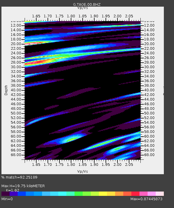
| Estimated Moho Depth: |
19.75 km |
| Estimated Crust Vp/Vs: |
1.62 |
| Assumed Crust Vp: |
4.24 km/s |
| Estimated Crust Vs: |
2.617 km/s |
| Estimated Crust Poisson's Ratio: |
0.19 |
|
| Radial Match: |
92.25189 % |
| Radial Bump: |
286 |
| Transverse Match: |
76.70078 % |
| Transverse Bump: |
400 |
| SOD ConfigId: |
21709731 |
| Insert Time: |
2020-07-07 15:41:07.941 +0000 |
| GWidth: |
2.5 |
| Max Bumps: |
400 |
| Tol: |
0.001 |
|

Signal To Noise
| Channel | StoN | STA | LTA |
| G:TAOE:00:BHZ:20200623T15:37:28.099998Z | 6.836792 | 7.3025885E-6 | 1.0681308E-6 |
| G:TAOE:00:BHN:20200623T15:37:28.099998Z | 2.5390832 | 2.516532E-6 | 9.911183E-7 |
| G:TAOE:00:BHE:20200623T15:37:28.099998Z | 3.9292545 | 3.764281E-6 | 9.580141E-7 |
| Arrivals |
| Ps | 3.0 SECOND |
| PpPs | 12 SECOND |
| PsPs/PpSs | 15 SECOND |


