You are here: Home > Network List > GS - US Geological Survey Networks Stations List
> Station KAN08 Pence Farm, Harper, KS, USA > Earthquake Result Viewer
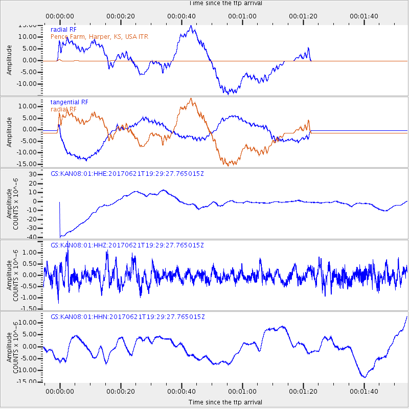
KAN08 Pence Farm, Harper, KS, USA - Earthquake Result Viewer
*The percent match for this event was below the threshold and hence no stack was calculated.
| Earthquake location: |
Rat Islands, Aleutian Islands |
| Earthquake latitude/longitude: |
51.8/179.4 |
| Earthquake time(UTC): |
2017/06/21 (172) 19:20:26 GMT |
| Earthquake Depth: |
165 km |
| Earthquake Magnitude: |
5.5 Mb |
| Earthquake Catalog/Contributor: |
NEIC PDE/at |
|
| Network: |
GS US Geological Survey Networks |
| Station: |
KAN08 Pence Farm, Harper, KS, USA |
| Lat/Lon: |
37.23 N/97.97 W |
| Elevation: |
375 m |
|
| Distance: |
57.6 deg |
| Az: |
69.672 deg |
| Baz: |
313.2 deg |
| Ray Param: |
$rayparam |
*The percent match for this event was below the threshold and hence was not used in the summary stack. |
|
| Radial Match: |
28.89319 % |
| Radial Bump: |
400 |
| Transverse Match: |
69.6182 % |
| Transverse Bump: |
400 |
| SOD ConfigId: |
2140511 |
| Insert Time: |
2017-07-05 11:23:02.869 +0000 |
| GWidth: |
2.5 |
| Max Bumps: |
400 |
| Tol: |
0.001 |
|
Signal To Noise
| Channel | StoN | STA | LTA |
| GS:KAN08:01:HHZ:20170621T19:29:27.765015Z | 1.4416058 | 5.2824817E-7 | 3.664304E-7 |
| GS:KAN08:01:HHN:20170621T19:29:27.765015Z | 0.85155714 | 8.119605E-6 | 9.535009E-6 |
| GS:KAN08:01:HHE:20170621T19:29:27.765015Z | 1.4292773 | 2.229085E-5 | 1.5595888E-5 |
| Arrivals |
| Ps | |
| PpPs | |
| PsPs/PpSs | |


