You are here: Home > Network List > IM - International Miscellaneous Stations Stations List
> Station SHEM Shemya Island, Alaska, USA > Earthquake Result Viewer
SHEM Shemya Island, Alaska, USA - Earthquake Result Viewer
| Earthquake location: |
Near Coast Of Oaxaca, Mexico |
| Earthquake latitude/longitude: |
15.9/-95.9 |
| Earthquake time(UTC): |
2020/06/23 (175) 15:29:04 GMT |
| Earthquake Depth: |
20 km |
| Earthquake Magnitude: |
7.4 mww |
| Earthquake Catalog/Contributor: |
NEIC PDE/us |
|
| Network: |
IM International Miscellaneous Stations |
| Station: |
SHEM Shemya Island, Alaska, USA |
| Lat/Lon: |
52.73 N/174.10 E |
| Elevation: |
580 m |
|
| Distance: |
77.5 deg |
| Az: |
321.465 deg |
| Baz: |
80.244 deg |
| Ray Param: |
0.050287783 |
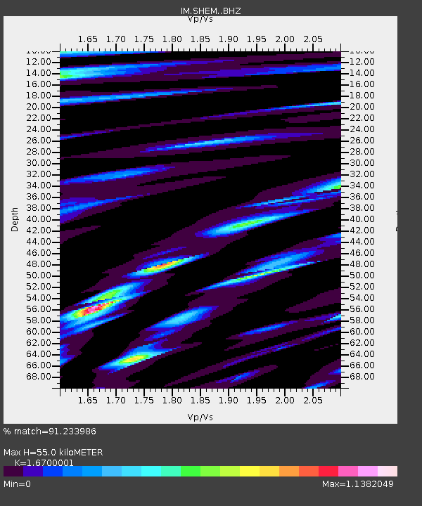
| Estimated Moho Depth: |
55.0 km |
| Estimated Crust Vp/Vs: |
1.67 |
| Assumed Crust Vp: |
3.999 km/s |
| Estimated Crust Vs: |
2.394 km/s |
| Estimated Crust Poisson's Ratio: |
0.22 |
|
| Radial Match: |
91.233986 % |
| Radial Bump: |
400 |
| Transverse Match: |
84.59 % |
| Transverse Bump: |
400 |
| SOD ConfigId: |
21709731 |
| Insert Time: |
2020-07-07 15:42:56.791 +0000 |
| GWidth: |
2.5 |
| Max Bumps: |
400 |
| Tol: |
0.001 |
|

Signal To Noise
| Channel | StoN | STA | LTA |
| IM:SHEM: :BHZ:20200623T15:40:27.098991Z | 43.780212 | 1.1610917E-5 | 2.6520925E-7 |
| IM:SHEM: :BHN:20200623T15:40:27.098991Z | 4.210473 | 1.65736E-6 | 3.93628E-7 |
| IM:SHEM: :BHE:20200623T15:40:27.098991Z | 10.870694 | 5.1635047E-6 | 4.749931E-7 |
| Arrivals |
| Ps | 9.3 SECOND |
| PpPs | 36 SECOND |
| PsPs/PpSs | 46 SECOND |


