You are here: Home > Network List > IW - Intermountain West Stations List
> Station DLMT Dillon, Montana, USA > Earthquake Result Viewer
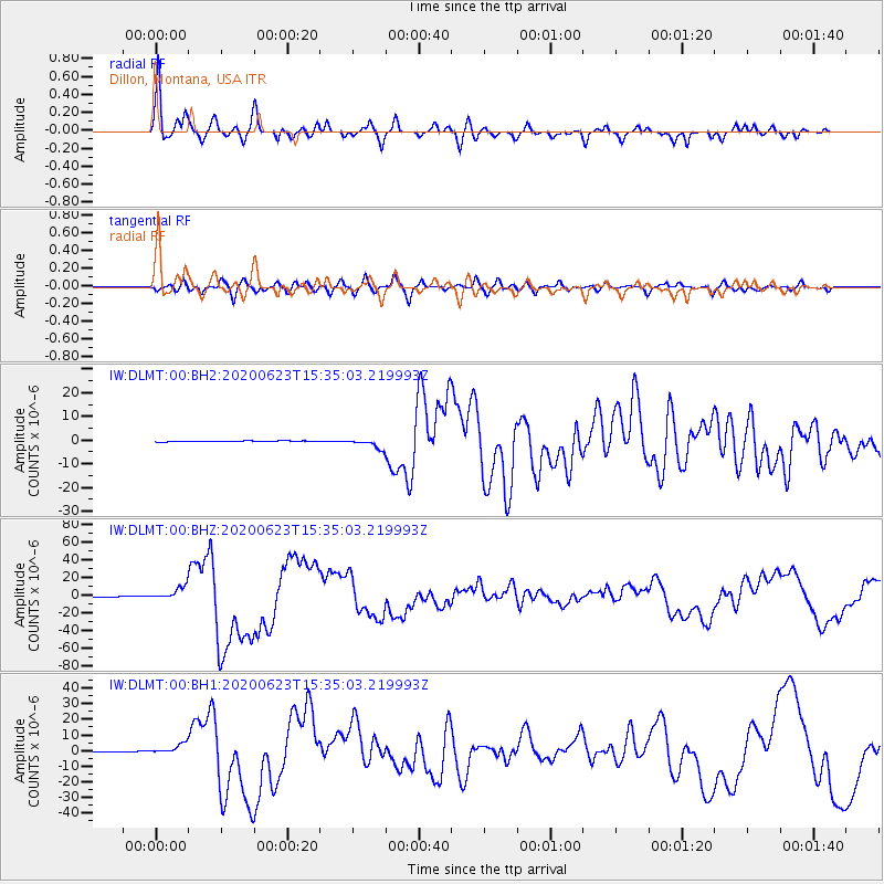
DLMT Dillon, Montana, USA - Earthquake Result Viewer

| Earthquake location: |
Near Coast Of Oaxaca, Mexico |
| Earthquake latitude/longitude: |
15.9/-95.9 |
| Earthquake time(UTC): |
2020/06/23 (175) 15:29:04 GMT |
| Earthquake Depth: |
20 km |
| Earthquake Magnitude: |
7.4 mww |
| Earthquake Catalog/Contributor: |
NEIC PDE/us |
|
| Network: |
IW Intermountain West |
| Station: |
DLMT Dillon, Montana, USA |
| Lat/Lon: |
45.36 N/112.60 W |
| Elevation: |
1569 m |
|
| Distance: |
32.5 deg |
| Az: |
337.912 deg |
| Baz: |
149.127 deg |
| Ray Param: |
0.07861105 |
| Estimated Moho Depth: |
63.0 km |
| Estimated Crust Vp/Vs: |
1.87 |
| Assumed Crust Vp: |
6.577 km/s |
| Estimated Crust Vs: |
3.522 km/s |
| Estimated Crust Poisson's Ratio: |
0.30 |
|
| Radial Match: |
89.215126 % |
| Radial Bump: |
395 |
| Transverse Match: |
76.61049 % |
| Transverse Bump: |
400 |
| SOD ConfigId: |
21709731 |
| Insert Time: |
2020-07-07 15:43:21.120 +0000 |
| GWidth: |
2.5 |
| Max Bumps: |
400 |
| Tol: |
0.001 |
|
Signal To Noise
| Channel | StoN | STA | LTA |
| IW:DLMT:00:BHZ:20200623T15:35:03.219993Z | 71.0096 | 7.246652E-6 | 1.0205173E-7 |
| IW:DLMT:00:BH1:20200623T15:35:03.219993Z | 14.3867 | 3.216027E-6 | 2.2354168E-7 |
| IW:DLMT:00:BH2:20200623T15:35:03.219993Z | 10.423641 | 2.0410325E-6 | 1.9580801E-7 |
| Arrivals |
| Ps | 9.0 SECOND |
| PpPs | 25 SECOND |
| PsPs/PpSs | 34 SECOND |


