You are here: Home > Network List > N4 - Central and EAstern US Network Stations List
> Station MDND Maddock, ND, USA > Earthquake Result Viewer
MDND Maddock, ND, USA - Earthquake Result Viewer
| Earthquake location: |
Near Coast Of Oaxaca, Mexico |
| Earthquake latitude/longitude: |
15.9/-95.9 |
| Earthquake time(UTC): |
2020/06/23 (175) 15:29:04 GMT |
| Earthquake Depth: |
20 km |
| Earthquake Magnitude: |
7.4 mww |
| Earthquake Catalog/Contributor: |
NEIC PDE/us |
|
| Network: |
N4 Central and EAstern US Network |
| Station: |
MDND Maddock, ND, USA |
| Lat/Lon: |
47.85 N/99.60 W |
| Elevation: |
479 m |
|
| Distance: |
32.0 deg |
| Az: |
355.334 deg |
| Baz: |
173.328 deg |
| Ray Param: |
0.0788469 |
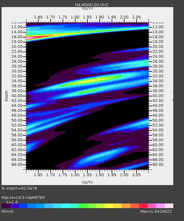
| Estimated Moho Depth: |
16.5 km |
| Estimated Crust Vp/Vs: |
1.60 |
| Assumed Crust Vp: |
6.53 km/s |
| Estimated Crust Vs: |
4.082 km/s |
| Estimated Crust Poisson's Ratio: |
0.18 |
|
| Radial Match: |
92.5676 % |
| Radial Bump: |
400 |
| Transverse Match: |
72.21681 % |
| Transverse Bump: |
400 |
| SOD ConfigId: |
21709731 |
| Insert Time: |
2020-07-07 15:44:51.763 +0000 |
| GWidth: |
2.5 |
| Max Bumps: |
400 |
| Tol: |
0.001 |
|

Signal To Noise
| Channel | StoN | STA | LTA |
| N4:MDND:00:HHZ:20200623T15:34:58.450004Z | 115.88189 | 2.7361319E-5 | 2.3611383E-7 |
| N4:MDND:00:HH1:20200623T15:34:58.450004Z | 76.167534 | 2.0430052E-5 | 2.682252E-7 |
| N4:MDND:00:HH2:20200623T15:34:58.450004Z | 13.736332 | 2.531221E-6 | 1.8427198E-7 |
| Arrivals |
| Ps | 1.7 SECOND |
| PpPs | 6.0 SECOND |
| PsPs/PpSs | 7.7 SECOND |


